IMAGES TAKEN NEAR TO
Burleys Road, BUCKINGHAM, MK18 3BA
Introduction
This page details the photographs taken nearby to Burleys Road, MK18 3BA by members of the Geograph project.
The Geograph project started in 2005 with the aim of publishing, organising and preserving representative images for every square kilometre of Great Britain, Ireland and the Isle of Man.

There are currently over 7.5m images from over14,400 individuals and you can help contribute to the project by visiting https://www.geograph.org.uk
Image Map
Images are licensed for reuse under creativecommons.org/licenses/by-sa/2.0
Notes
- Clicking on the map will re-center to the selected point.
- The higher the marker number, the further away the image location is from the centre of the postcode.
Image Listing (76 Images Found)
Images are licensed for reuse under creativecommons.org/licenses/by-sa/2.0
Image
Details
Distance
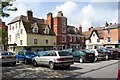
4
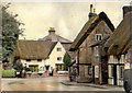
Horn Street, Winslow
Pretty houses on a bend in Horn Street with St Laurence's church tower in the background.
Image: © mick finn
Taken: 23 Nov 2008
0.10 miles
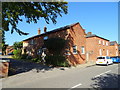
8
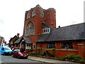
Congregational church, Winslow
Built in 1884. See http://www.geograph.org.uk/photo/4137156 for a photo of the foundation stone.
Image: © Bikeboy
Taken: 21 Aug 2014
0.11 miles
9

Congregational church, Winslow, foundation stone
See http://www.geograph.org.uk/photo/4137154 for a picture of the church.
Image: © Bikeboy
Taken: 21 Aug 2014
0.11 miles