IMAGES TAKEN NEAR TO
Verney Junction, BUCKINGHAM, MK18 2JZ
Introduction
This page details the photographs taken nearby to MK18 2JZ by members of the Geograph project.
The Geograph project started in 2005 with the aim of publishing, organising and preserving representative images for every square kilometre of Great Britain, Ireland and the Isle of Man.

There are currently over 7.5m images from over14,400 individuals and you can help contribute to the project by visiting https://www.geograph.org.uk
Image Map
Images are licensed for reuse under creativecommons.org/licenses/by-sa/2.0
Notes
- Clicking on the map will re-center to the selected point.
- The higher the marker number, the further away the image location is from the centre of the postcode.
Image Listing (31 Images Found)
Images are licensed for reuse under creativecommons.org/licenses/by-sa/2.0
Image
Details
Distance
1
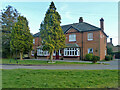
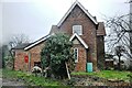
The Verney Arms, Verney Junction, 2014
Was this a pub, a straight hotel, a restaurant or what at this date?
Image: © Robin Webster
Taken: 22 Feb 2014
0.03 miles
2
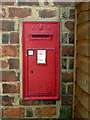
Victorian postbox at Verney Junction
Image: © Philip Jeffrey
Taken: 16 Jul 2013
0.03 miles
3
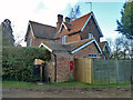
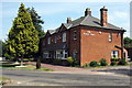
The Station House, Verney Junction
Called later 'Rayside', although the original title is still displayed in bigger letters. The station and line are closed.
Image: © Robin Webster
Taken: 22 Feb 2014
0.03 miles
4
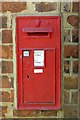
Victorian postbox on the former station house
Image: © Steve Daniels
Taken: 21 Apr 2015
0.03 miles
5
The old Station House at Verney Junction
The LNWR line from Bletchley to Oxford opened in 1850 and was joined by the Aylesbury & Buckingham Railway in 1868 when Verney Junction Station opened. At the time the station was sited in the middle of a field and was only used as a changing point between the two lines. The Station House dates from 1870 as the sign over the door proclaims. Verney Junction has always been only a hamlet with station, a hotel and a few houses dotted around and seems destined to remain so. No station is planned here for the East West Railway, the nearest being the new station at Winslow to the east.
Image: © Bob Walters
Taken: 25 Jan 2022
0.03 miles
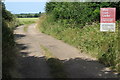
7
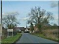
Verney Road enters Verney Junction
Not a big place, with no railway junction or station anymore, or even an operational railway at this 2014 date.
Image: © Robin Webster
Taken: 22 Feb 2014
0.04 miles
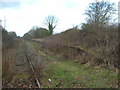
8
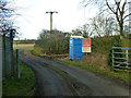
Level crossing at Verney Junction
The line is 'mothballed', but clearance of vegetation is in hand as a preliminary to reopening for passenger traffic some years ahead. The cabin is for the convenience of those working on this. No through rail traffic is yet possible because of obstacles at certain points such as fences and displaced rails. There is a faint suggestion that some rail vehicle, presumably a road-rail vehicle or trolley, has gone west from this point, but not the other way.
Image: © Robin Webster
Taken: 22 Feb 2014
0.04 miles
9
Disused railway crosses the North Bucks Way
Image: © Philip Jeffrey
Taken: 16 Jul 2013
0.04 miles
10
Disused Platform at Verney Junction
The overgrown platform at Verney Junction on the dismantled side of the track
Image: © Mr Biz
Taken: 27 Mar 2010
0.04 miles