IMAGES TAKEN NEAR TO
Addington, BUCKINGHAM, MK18 2JS
Introduction
This page details the photographs taken nearby to MK18 2JS by members of the Geograph project.
The Geograph project started in 2005 with the aim of publishing, organising and preserving representative images for every square kilometre of Great Britain, Ireland and the Isle of Man.

There are currently over 7.5m images from over14,400 individuals and you can help contribute to the project by visiting https://www.geograph.org.uk
Image Map (Loading...)


Getting Data...Please wait
Leaflet Map data © OpenStreetMap
Images are licensed for reuse under creativecommons.org/licenses/by-sa/2.0
Notes
- Clicking on the map will re-center to the selected point.
- The higher the marker number, the further away the image location is from the centre of the postcode.
Image Listing (4 Images Found)
Images are licensed for reuse under creativecommons.org/licenses/by-sa/2.0
Image
Details
Distance
2
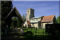
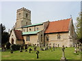
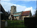
Church of St Mary the Virgin
Addington is a small hamlet close to Buckingham a large part of which is now an Equestrian centre. The church dates back to 1220 when records first began.
Image: © Mel Braithwaite
Taken: 19 Apr 2007
0.14 miles
4
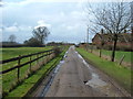
Farm road to Hill Farm
According to my OS map, this track leads in the direction of Hill Farm from the hamlet of Addington.
Image: © Mr Biz
Taken: 27 Mar 2010
0.21 miles