IMAGES TAKEN NEAR TO
Northlands Road, BUCKINGHAM, MK18 2JH
Introduction
This page details the photographs taken nearby to Northlands Road, MK18 2JH by members of the Geograph project.
The Geograph project started in 2005 with the aim of publishing, organising and preserving representative images for every square kilometre of Great Britain, Ireland and the Isle of Man.

There are currently over 7.5m images from over14,400 individuals and you can help contribute to the project by visiting https://www.geograph.org.uk
Image Map
Images are licensed for reuse under creativecommons.org/licenses/by-sa/2.0
Notes
- Clicking on the map will re-center to the selected point.
- The higher the marker number, the further away the image location is from the centre of the postcode.
Image Listing (35 Images Found)
Images are licensed for reuse under creativecommons.org/licenses/by-sa/2.0
Image
Details
Distance
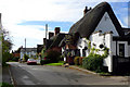
4
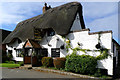
The Thatched Inn and Restaurant, Adstock
The date on the signboard is c1645.
Image: © Cameraman
Taken: 21 Oct 2010
0.13 miles
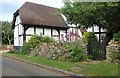
5
The Thatched Inn and Restaurant in Adstock village
Image: © Cameraman
Taken: 21 Oct 2010
0.13 miles
10
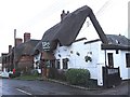
The Thatched Inn & Restaurant, Adstock
According to the sign, this inn and restaurant on Main Street in Adstock dates from 1645.
Image: © Rob Farrow
Taken: 23 Feb 2007
0.14 miles