IMAGES TAKEN NEAR TO
St. Marys Close, BUCKINGHAM, MK18 2HR
Introduction
This page details the photographs taken nearby to St. Marys Close, MK18 2HR by members of the Geograph project.
The Geograph project started in 2005 with the aim of publishing, organising and preserving representative images for every square kilometre of Great Britain, Ireland and the Isle of Man.

There are currently over 7.5m images from over14,400 individuals and you can help contribute to the project by visiting https://www.geograph.org.uk
Image Map (Loading...)


Getting Data...Please wait
Leaflet Map data © OpenStreetMap
Images are licensed for reuse under creativecommons.org/licenses/by-sa/2.0
Notes
- Clicking on the map will re-center to the selected point.
- The higher the marker number, the further away the image location is from the centre of the postcode.
Image Listing (31 Images Found)
Images are licensed for reuse under creativecommons.org/licenses/by-sa/2.0
Image
Details
Distance
1
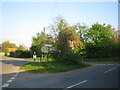
Tree stump, East Claydon
The tree stump at the road junction in the centre of East Claydon is one of the huge number of elm trees in Britain that died from Dutch Elm Disease since the late 1960s.
Image: © Andy Gryce
Taken: 22 Apr 2007
0.05 miles
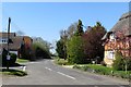
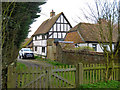
2
Road junction, East Claydon
There is an ivy-covered tree stump on the island, and the 17C house to the right is White House, formerly a farmhouse.
Image: © Humphrey Bolton
Taken: 30 Jan 2022
0.06 miles
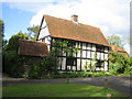
4
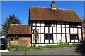
Fletchers, East Claydon
A 17C house, dated 1641.
Image: © Humphrey Bolton
Taken: 30 Jan 2022
0.07 miles
5
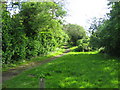
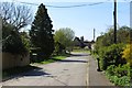
Footpath, Church Way , East Claydon
This is the start of a footpath at the end of Church Way in East Claydon near the church and vicarage, which is off camera to the left. It runs south-west, with farmland to the east and the edge of the village to the west, to join St Mary's Road halfway between East Claydon and Botolph Claydon.
Image: © Andy Gryce
Taken: 12 May 2007
0.07 miles
7
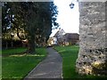
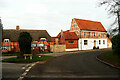
Churchyard of St Mary's and Beech House, East Claydon
Beech House dates from C17. See http://www.britishlistedbuildings.co.uk/en-396654-beech-house-east-claydon-buckinghamshire for entry in British Listed Buildings
Image: © Bikeboy
Taken: 2 Jan 2015
0.08 miles
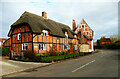
8
Beech House, Church Way, East Claydon
This Elizabethan house is on a small triangular green at the end of Church Way on the eastern edge of the village of East Claydon. The gate to the parish church, St Mary the Virgin, is just off camera to the right, see Image
Image: © Andy Gryce
Taken: 12 May 2007
0.09 miles
9
Beech House, East Claydon
The older, timbered part is 17th century. Grade II listed. Viewed from the churchyard.
Image: © Robin Webster
Taken: 27 Mar 2015
0.09 miles