IMAGES TAKEN NEAR TO
Taylor Close, BUCKINGHAM, MK18 2GG
Introduction
This page details the photographs taken nearby to Taylor Close, MK18 2GG by members of the Geograph project.
The Geograph project started in 2005 with the aim of publishing, organising and preserving representative images for every square kilometre of Great Britain, Ireland and the Isle of Man.

There are currently over 7.5m images from over14,400 individuals and you can help contribute to the project by visiting https://www.geograph.org.uk
Image Map
Images are licensed for reuse under creativecommons.org/licenses/by-sa/2.0
Notes
- Clicking on the map will re-center to the selected point.
- The higher the marker number, the further away the image location is from the centre of the postcode.
Image Listing (16 Images Found)
Images are licensed for reuse under creativecommons.org/licenses/by-sa/2.0
Image
Details
Distance
2
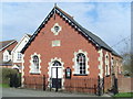
Steeple Claydon Methodist Church, Bucks
This Wesleyan Chapel in West Street was built in 1862 and extended in 1893. It is one of eight churches in the Buckingham, Bicester and Brackley Methodist Circuit. Services are held here each Sunday at 6.00pm. Its postcode is MK18 2NS.
Image: © David Hillas
Taken: 9 Apr 2010
0.04 miles
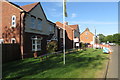
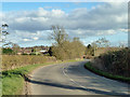
4

West Street crosses Hog Bridge into Steeple Claydon
Image: © Steve Daniels
Taken: 1 Jul 2014
0.06 miles
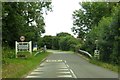
5
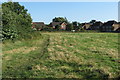
The road to Steeple Claydon
The village, but not the steeple, is visible ahead.
Image: © Robin Webster
Taken: 22 Feb 2014
0.08 miles
6

Fine collection of trees on West Street
Image: © Philip Jeffrey
Taken: 7 Aug 2016
0.10 miles

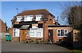
8
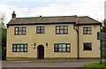
The former Seven Stars on Addison Road
Image: © Steve Daniels
Taken: 1 Jul 2014
0.13 miles