IMAGES TAKEN NEAR TO
Rustics Close, BUCKINGHAM, MK18 2FG
Introduction
This page details the photographs taken nearby to Rustics Close, MK18 2FG by members of the Geograph project.
The Geograph project started in 2005 with the aim of publishing, organising and preserving representative images for every square kilometre of Great Britain, Ireland and the Isle of Man.

There are currently over 7.5m images from over14,400 individuals and you can help contribute to the project by visiting https://www.geograph.org.uk
Image Map
Images are licensed for reuse under creativecommons.org/licenses/by-sa/2.0
Notes
- Clicking on the map will re-center to the selected point.
- The higher the marker number, the further away the image location is from the centre of the postcode.
Image Listing (9 Images Found)
Images are licensed for reuse under creativecommons.org/licenses/by-sa/2.0
Image
Details
Distance
1
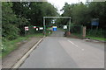
Entrance to the landfill site
Bridleway goes off to the left
Image: © Philip Jeffrey
Taken: 26 Jul 2020
0.17 miles
5
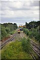
Calvert waste depot and Greatmoor EFW incinerator
Class 66 No. 66078 running back to the Calvert waste terminal. Its train of waste containers is being unloaded to be returned later to London. The Greatmoor EFW (Energy From Waste) incinerator is in the background. This takes waste products both by rail and road to produce 'green' electricity.
Image: © Bob Walters
Taken: 19 Aug 2021
0.23 miles
6
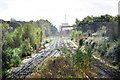
Calvert waste depot and Greatmoor EFW incinerator
Two months on from the previous picture with this title (6937388), all trackwork passing the remains of the old Calvert Station platforms has been removed in readiness for the continuation of HS2 works. The waste terminal will be rebuilt to the left and HS2 tracks will pass through where the photographer is standing.
Image: © Bob Walters
Taken: 25 Oct 2021
0.23 miles
8
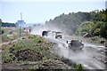
Dust and tipper trucks
A continuous procession of tipper trucks carrying stone for the HS2 and EWR works at the site of the old Calvert GCR Station. HS2 is due to pass through here and the new EWR tracks will cross over it just north of here.
Image: © Bob Walters
Taken: 11 Aug 2022
0.24 miles
9
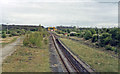
Remains of Calvert station, 1984
View SE, towards Grendon Underwood Junction, Quainton Road, Aylesbury and London Marylebone: ex-GC Marylebone - Sheffield main line. The station was closed 4/3/63 (goods, 4/5/64), the main line from 5/9/66. A loop from Claydon on the ex-LNW Bletchley - Oxford line, opened 14/9/40 as a wartime connection, remained until 22/11/65. The tracks visible here serve primarily the large Waste Depot (former quarry) and come from Aylesbury via Quainton Road.
Image: © Ben Brooksbank
Taken: 7 May 1984
0.25 miles