IMAGES TAKEN NEAR TO
Steeple Claydon, BUCKINGHAM, MK18 2ES
Introduction
This page details the photographs taken nearby to MK18 2ES by members of the Geograph project.
The Geograph project started in 2005 with the aim of publishing, organising and preserving representative images for every square kilometre of Great Britain, Ireland and the Isle of Man.

There are currently over 7.5m images from over14,400 individuals and you can help contribute to the project by visiting https://www.geograph.org.uk
Image Map
Images are licensed for reuse under creativecommons.org/licenses/by-sa/2.0
Notes
- Clicking on the map will re-center to the selected point.
- The higher the marker number, the further away the image location is from the centre of the postcode.
Image Listing (4 Images Found)
Images are licensed for reuse under creativecommons.org/licenses/by-sa/2.0
Image
Details
Distance
1
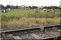
Old railway track
The Bernwood Way cuts across the old railway track heading up through the bird hutches at Rectory farm
Image: © Shaun Ferguson
Taken: 21 Sep 2007
0.07 miles
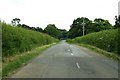
2

Railway track heading towards Winslow
Forms part of the old Oxford-Cambridge route. Site of an old railway station.
Image: © Jon S
Taken: 28 Sep 2005
0.12 miles
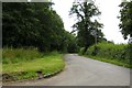
4
Queen Catherine Road to Middle Claydon
Image: © Steve Daniels
Taken: 1 Jul 2014
0.22 miles