IMAGES TAKEN NEAR TO
Padbury Road, BUCKINGHAM, MK18 2EB
Introduction
This page details the photographs taken nearby to Padbury Road, MK18 2EB by members of the Geograph project.
The Geograph project started in 2005 with the aim of publishing, organising and preserving representative images for every square kilometre of Great Britain, Ireland and the Isle of Man.

There are currently over 7.5m images from over14,400 individuals and you can help contribute to the project by visiting https://www.geograph.org.uk
Image Map
Images are licensed for reuse under creativecommons.org/licenses/by-sa/2.0
Notes
- Clicking on the map will re-center to the selected point.
- The higher the marker number, the further away the image location is from the centre of the postcode.
Image Listing (13 Images Found)
Images are licensed for reuse under creativecommons.org/licenses/by-sa/2.0
Image
Details
Distance
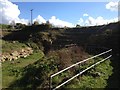
1
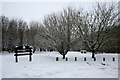
Gated Path, Coombs, Bucks
Gated path leading to open space adjacent to Thornborough Community Woodland Nature Reserve. A picnic table can just be seen centre left, middle distance.
Image: © mick finn
Taken: 22 Mar 2009
0.06 miles
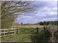
4
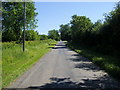
Road to Adstock
By Coombs the road to Adstock
Image: © Shaun Ferguson
Taken: 16 Jun 2010
0.11 miles
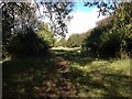
5
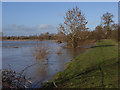
Padbury Brook in flood
Beside the footpath between Coombs and Thornborough Bridge.
Image: © Andrew Smith
Taken: 11 Feb 2007
0.12 miles
6
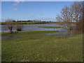
Padbury Brook in flood
Looking across the brook, which is in the foreground, to Bourton Grounds. At this point it has mostly flooded the flatter land on its western side.
Image: © Andrew Smith
Taken: 11 Feb 2007
0.13 miles

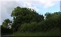
9
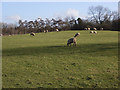
Sheep at Coombs
Beside the Coombs Quarry nature reserve.
Image: © Andrew Smith
Taken: 11 Feb 2007
0.20 miles