IMAGES TAKEN NEAR TO
West Furlong, BUCKINGHAM, MK18 2BP
Introduction
This page details the photographs taken nearby to West Furlong, MK18 2BP by members of the Geograph project.
The Geograph project started in 2005 with the aim of publishing, organising and preserving representative images for every square kilometre of Great Britain, Ireland and the Isle of Man.

There are currently over 7.5m images from over14,400 individuals and you can help contribute to the project by visiting https://www.geograph.org.uk
Image Map (Loading...)


Getting Data...Please wait
Leaflet Map data © OpenStreetMap
Images are licensed for reuse under creativecommons.org/licenses/by-sa/2.0
Notes
- Clicking on the map will re-center to the selected point.
- The higher the marker number, the further away the image location is from the centre of the postcode.
Image Listing (13 Images Found)
Images are licensed for reuse under creativecommons.org/licenses/by-sa/2.0
Image
Details
Distance
1
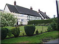
Cottage Old End Padbury
Pretty cottage on the west side of Old End
Image: © Tom Dickens
Taken: 28 May 2007
0.12 miles
2
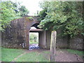
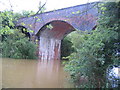
The Cattle Arch
The Padbury Cattle Arch and the disused railway.
Image: © Tom Dickens
Taken: 29 May 2007
0.14 miles
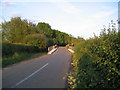
3
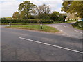
Road junction and grass triangle
The minor road to Gawcott
Image: © Michael Trolove
Taken: 10 May 2017
0.18 miles
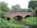
5
Padbury Viaduct
Padbury Viaduct over the Padbury brook.
Image: © Tom Dickens
Taken: 29 May 2007
0.22 miles
7
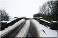
Oxlane Bridge.
Looking South to Padbury and Steeple Claydon from Lenborough
Image: © Tom Dickens
Taken: 31 May 2007
0.23 miles
8
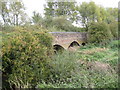
Padbury: Oxlane Bridge
Oxlane Bridge carries the road over Padbury Brook. Under normal flow conditions the brook only flows through the centre arch, the other two smaller arches to either side being flood arches.
Image: © Nigel Cox
Taken: 17 Oct 2010
0.23 miles
10
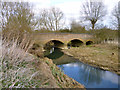
Oxlane Bridge
Over Padbury Brook, a major tributary of the Great Ouse. It appears to have been very much higher some time in the winter.
Image: © Robin Webster
Taken: 27 Mar 2015
0.23 miles