IMAGES TAKEN NEAR TO
Kenelm Street, BUCKINGHAM, MK18 1ZS
Introduction
This page details the photographs taken nearby to Kenelm Street, MK18 1ZS by members of the Geograph project.
The Geograph project started in 2005 with the aim of publishing, organising and preserving representative images for every square kilometre of Great Britain, Ireland and the Isle of Man.

There are currently over 7.5m images from over14,400 individuals and you can help contribute to the project by visiting https://www.geograph.org.uk
Image Map
Images are licensed for reuse under creativecommons.org/licenses/by-sa/2.0
Notes
- Clicking on the map will re-center to the selected point.
- The higher the marker number, the further away the image location is from the centre of the postcode.
Image Listing (17 Images Found)
Images are licensed for reuse under creativecommons.org/licenses/by-sa/2.0
Image
Details
Distance
2
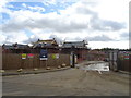
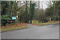
Development site off Tingewick Road
This land will support a lot of new housing on the edge of Buckingham.
Image: © Bill Boaden
Taken: 24 Nov 2018
0.17 miles
6
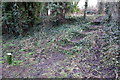
Steps from the Railway Walk to the wildlife area
Image: © Philip Jeffrey
Taken: 13 Jan 2013
0.18 miles
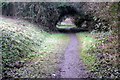
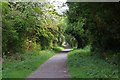
8
Footpath down to a former railway
The former railway to Banbury is now part of the Ouse Valley Way.
Image: © Bill Boaden
Taken: 24 Nov 2018
0.20 miles
9
Railway cutting
Looking SE from the site of the former bridge under Tingewick Road. Buckingham was a station on the London & North-Western Railway branch from Verney Junction to Banbury. This section of line is now a well-kept path.
Image: © Fractal Angel
Taken: 29 Apr 2007
0.21 miles