IMAGES TAKEN NEAR TO
Hilltop Avenue, BUCKINGHAM, MK18 1YL
Introduction
This page details the photographs taken nearby to Hilltop Avenue, MK18 1YL by members of the Geograph project.
The Geograph project started in 2005 with the aim of publishing, organising and preserving representative images for every square kilometre of Great Britain, Ireland and the Isle of Man.

There are currently over 7.5m images from over14,400 individuals and you can help contribute to the project by visiting https://www.geograph.org.uk
Image Map
Images are licensed for reuse under creativecommons.org/licenses/by-sa/2.0
Notes
- Clicking on the map will re-center to the selected point.
- The higher the marker number, the further away the image location is from the centre of the postcode.
Image Listing (17 Images Found)
Images are licensed for reuse under creativecommons.org/licenses/by-sa/2.0
Image
Details
Distance
1
Benchmark on the garage of #1 Busby Close
Ordnance Survey cut mark benchmark described on the Bench Mark Database at http://www.bench-marks.org.uk/bm36897
Image: © Roger Templeman
Taken: 11 Feb 2011
0.04 miles
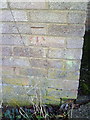
2
Benchmark on #24Hilltop Avenue
Ordnance Survey cut mark benchmark described on the Bench Mark Database at http://www.bench-marks.org.uk/bm36900
Image: © Roger Templeman
Taken: 11 Feb 2011
0.08 miles
4
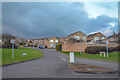
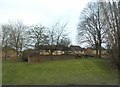
Buckingham : Page Hill Avenue
Looking up the road from the roundabout.
Image: © Lewis Clarke
Taken: 18 Mar 2019
0.12 miles
6
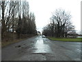
Service Road by Stratford Road, Buckingham
Image: © David Howard
Taken: 4 Feb 2018
0.15 miles
7
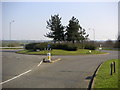
A422 Buckingham roundabout
Where the A413 and the A422 meet, this photo was taken from the north side, just on the edge of the Page Hill part of Buckingham.
Image: © Mr Biz
Taken: 1 Apr 2007
0.15 miles
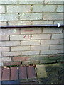
9
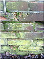
Damaged benchmark on wall by garages on Stratford Road
Ordnance Survey cut mark benchmark described on the Bench Mark Benchmark at http://www.bench-marks.org.uk/bm36896
Image: © Roger Templeman
Taken: 11 Feb 2011
0.15 miles
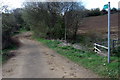
10
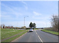
Old A422 (disused) Buckingham
Looking towards the roundabout at the junction of the A422, Stratford Rd, and the A413 from the old A422, diverted some 30 years ago.
Image: © mick finn
Taken: 6 Oct 2008
0.16 miles