IMAGES TAKEN NEAR TO
Gawcott Road, BUCKINGHAM, MK18 1TN
Introduction
This page details the photographs taken nearby to Gawcott Road, MK18 1TN by members of the Geograph project.
The Geograph project started in 2005 with the aim of publishing, organising and preserving representative images for every square kilometre of Great Britain, Ireland and the Isle of Man.

There are currently over 7.5m images from over14,400 individuals and you can help contribute to the project by visiting https://www.geograph.org.uk
Image Map
Images are licensed for reuse under creativecommons.org/licenses/by-sa/2.0
Notes
- Clicking on the map will re-center to the selected point.
- The higher the marker number, the further away the image location is from the centre of the postcode.
Image Listing (5 Images Found)
Images are licensed for reuse under creativecommons.org/licenses/by-sa/2.0
Image
Details
Distance
1
Field by Gawcott Fields Farm
The field is in use for grazing sheep and is surrounded by an electrified fence.
Image: © Bill Boaden
Taken: 24 Nov 2018
0.05 miles
2

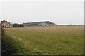
Field near Gawcott Fields Farm
On the east side of Gawcott Road. Buckingham Industrial Estate is seen in the distance.
Image: © Bill Boaden
Taken: 24 Nov 2018
0.06 miles
3

Old Milepost by Gawcott Road, north east of Gawcott
Bucks pressing by the UC road, in parish of Buckingham (Aylesbury Vale District), Gawcott, by the road.
Inscription reads:- : BRILL / 15 : BUCKINGHAM / PARISH : : BUCKINGHAM / 1 :
Lost since 1970.
Milestone Society National ID: BU_BRBU15
Image: © Milestone Society
Taken: Unknown
0.13 miles
4
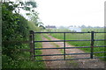
Track up to farm buildings
Stile hidden next to gate of track up to farm buildings. Path down to Gawcott
Image: © Shaun Ferguson
Taken: 8 Jun 2007
0.13 miles
5
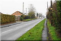
Gawcott Road
A road leading from Buckingham to Gawcott, seen here on the fringes of Buckingham.
Image: © Bill Boaden
Taken: 24 Nov 2018
0.19 miles