IMAGES TAKEN NEAR TO
Lenborough, BUCKINGHAM, MK18 1TA
Introduction
This page details the photographs taken nearby to MK18 1TA by members of the Geograph project.
The Geograph project started in 2005 with the aim of publishing, organising and preserving representative images for every square kilometre of Great Britain, Ireland and the Isle of Man.

There are currently over 7.5m images from over14,400 individuals and you can help contribute to the project by visiting https://www.geograph.org.uk
Image Map
Images are licensed for reuse under creativecommons.org/licenses/by-sa/2.0
Notes
- Clicking on the map will re-center to the selected point.
- The higher the marker number, the further away the image location is from the centre of the postcode.
Image Listing (9 Images Found)
Images are licensed for reuse under creativecommons.org/licenses/by-sa/2.0
Image
Details
Distance
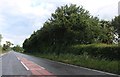
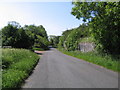
1
Road Junction
From the main road, you can either turn off down towards Padbury, or continue along the road towards Gawcott. In the background is Laurel House.
Image: © Mr Biz
Taken: 1 Apr 2007
0.03 miles
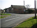
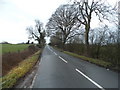
2
Part of an old railway bridge by Laurel House
Image: © Philip Jeffrey
Taken: 22 Jan 2013
0.14 miles
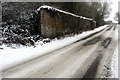
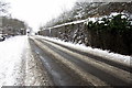
3
Remains of railway bridge
An acute skew bridge over the road was here. The railway was the LNWR Verney Junction to Banbury route. This section, the last to survive, was abandoned in 1966.
Image: © Robin Webster
Taken: 27 Mar 2015
0.14 miles
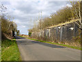
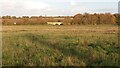
4
Skew Bridge Lenborough
The remains of Skew Bridge near to the Laurels Farm House Lenborough
Image: © Tom Dickens
Taken: 1 Jun 2007
0.15 miles
7
Path heading to Padbury Bridge
From Lenborough the path heading to Padbury Bridge
Image: © Shaun Ferguson
Taken: 26 Oct 2020
0.23 miles