IMAGES TAKEN NEAR TO
Tingewick Road, BUCKINGHAM, MK18 1ST
Introduction
This page details the photographs taken nearby to Tingewick Road, MK18 1ST by members of the Geograph project.
The Geograph project started in 2005 with the aim of publishing, organising and preserving representative images for every square kilometre of Great Britain, Ireland and the Isle of Man.

There are currently over 7.5m images from over14,400 individuals and you can help contribute to the project by visiting https://www.geograph.org.uk
Image Map
Images are licensed for reuse under creativecommons.org/licenses/by-sa/2.0
Notes
- Clicking on the map will re-center to the selected point.
- The higher the marker number, the further away the image location is from the centre of the postcode.
Image Listing (18 Images Found)
Images are licensed for reuse under creativecommons.org/licenses/by-sa/2.0
Image
Details
Distance
1
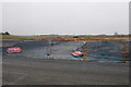
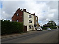
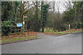
Development site off Tingewick Road
This land will support a lot of new housing on the edge of Buckingham.
Image: © Bill Boaden
Taken: 24 Nov 2018
0.03 miles
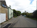
6
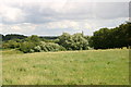
The Bernwood Way
The Bernwood Way heads across the field heading towards Buckingham
Image: © Shaun Ferguson
Taken: 7 Jul 2007
0.09 miles
7
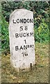
Old Milestone on Tingewick Road, west of Buckingham
Carved stone post by the UC road, in parish of Buckingham (Aylesbury Vale District), Tingewick Road; opposite Field House Day Nursery, on wide, well cut grass verge, on South side of road. Aynho pillar, erected by the Buckingham & Hanwell (Lower Division) turnpike trust in the 18th century.
Inscription reads:-
LONDON
58
BUCKM
1
BANBRY
16
Buckinghamshire HER.
HER Number: 1359900000 https://www.heritagegateway.org.uk/Gateway/Results_Single.aspx?uid=MBC25790&resourceID=1024
Milestone Society National ID: BU_LC58
Image: © A Rosevear & J Higgins
Taken: 25 Jul 2002
0.10 miles
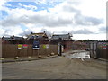
9
Bernwood Jubilee Way by the industrial estate
Image: © Philip Jeffrey
Taken: 13 Jan 2013
0.11 miles
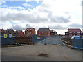
10
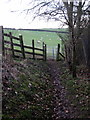
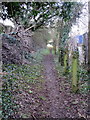
Footpath down to a former railway
The former railway to Banbury is now part of the Ouse Valley Way.
Image: © Bill Boaden
Taken: 24 Nov 2018
0.16 miles