IMAGES TAKEN NEAR TO
Manor Gardens, BUCKINGHAM, MK18 1RJ
Introduction
This page details the photographs taken nearby to Manor Gardens, MK18 1RJ by members of the Geograph project.
The Geograph project started in 2005 with the aim of publishing, organising and preserving representative images for every square kilometre of Great Britain, Ireland and the Isle of Man.

There are currently over 7.5m images from over14,400 individuals and you can help contribute to the project by visiting https://www.geograph.org.uk
Image Map
Images are licensed for reuse under creativecommons.org/licenses/by-sa/2.0
Notes
- Clicking on the map will re-center to the selected point.
- The higher the marker number, the further away the image location is from the centre of the postcode.
Image Listing (5 Images Found)
Images are licensed for reuse under creativecommons.org/licenses/by-sa/2.0
Image
Details
Distance
1
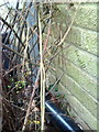
Benchmark partly hidden by shrubs on side of #13 King Charles Close
Ordnance Survey cut mark benchmark described on the Bench Mark Database at http://www.bench-marks.org.uk/bm36901
Image: © Roger Templeman
Taken: 11 Feb 2011
0.15 miles
3

St. Edmund's, Maids' Moreton
The church tower of St. Edmund's, Maids' Moreton.
Image: © mick finn
Taken: 18 Oct 2008
0.22 miles
4

Porch, St. Edmund's
The porch at the west end of St. Edmund's church, Maids' Moreton. The first recorded rector was Robert, 1241.
Image: © mick finn
Taken: 18 Oct 2008
0.22 miles
5

Porch, St. Edmund's
The porch at the west end of St. Edmund's, Maids' Moreton. The first recorded rector was Robert, in 1241. Part of the graveyard can be seen in the distance.
Image: © mick finn
Taken: 18 Oct 2008
0.22 miles