IMAGES TAKEN NEAR TO
The Chewar, BUCKINGHAM, MK18 1NG
Introduction
This page details the photographs taken nearby to The Chewar, MK18 1NG by members of the Geograph project.
The Geograph project started in 2005 with the aim of publishing, organising and preserving representative images for every square kilometre of Great Britain, Ireland and the Isle of Man.

There are currently over 7.5m images from over14,400 individuals and you can help contribute to the project by visiting https://www.geograph.org.uk
Image Map
Images are licensed for reuse under creativecommons.org/licenses/by-sa/2.0
Notes
- Clicking on the map will re-center to the selected point.
- The higher the marker number, the further away the image location is from the centre of the postcode.
Image Listing (183 Images Found)
Images are licensed for reuse under creativecommons.org/licenses/by-sa/2.0
Image
Details
Distance
1
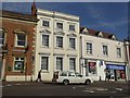
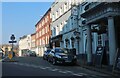
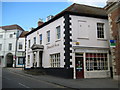
Where's the door? Facade in Buckingham
The central building has no door onto the street; presumably it is linked to a neighbour
Image: © David Smith
Taken: 25 Aug 2017
0.01 miles
3
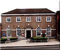
Buckingham Post Office
The date-stone above the entrance attests that the post office was built in 1939. The opening date was 27 July 1939, and the architect was Frederick Allen Llewellyn of the Office of Works.
Image: © Jim Osley
Taken: 11 Aug 2015
0.01 miles
4
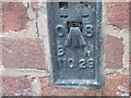
Ordnance Survey Flush Bracket 11029
This can be found on the wall of the Town Hall.
For more detail see : http://www.bench-marks.org.uk/bm703
Image: © Peter Wood
Taken: 30 Nov 2012
0.01 miles
6
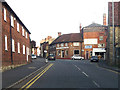
The Buckingham Fort ahead
On the corner of West Street and School Lane
Image: © John Firth
Taken: 22 Sep 2012
0.02 miles
8
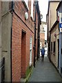
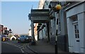
The Chewar
The Chewar, Buckingham, a narrow passageway, name perhaps linked to a Butchery?
Image: © Snidge
Taken: 28 Jun 2007
0.02 miles
9
Buckingham: The Chewar & 1 West Street
The Chewar is a narrow passageway that runs from West Street here, between the Russell & Butler estate agency and Lloyds TSB Bank, round to Market Hill. It has a typical small Buckingham town street name plate just above the yellow burglar alarm. The name of The Chewar, or just Chewar as it is shown on the Ordnance Survey town map of 1881, probably gets its derivation from the same source as the word chare, commonly used in Newcastle-upon-Tyne as a name for a narrow lane, alley, or wynd. For a view looking into The Chewar please see Image The Russell & Butler website is here http://www.russellandbutler.com/
Image: © Nigel Cox
Taken: 17 Oct 2010
0.02 miles
10
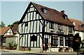
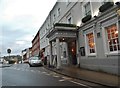
The Tudor Buckingham
Different road layout from "The Tudor Rock"
Image: © N T Stobbs
Taken: Unknown
0.02 miles