IMAGES TAKEN NEAR TO
Western Avenue, BUCKINGHAM, MK18 1LN
Introduction
This page details the photographs taken nearby to Western Avenue, MK18 1LN by members of the Geograph project.
The Geograph project started in 2005 with the aim of publishing, organising and preserving representative images for every square kilometre of Great Britain, Ireland and the Isle of Man.

There are currently over 7.5m images from over14,400 individuals and you can help contribute to the project by visiting https://www.geograph.org.uk
Image Map
Images are licensed for reuse under creativecommons.org/licenses/by-sa/2.0
Notes
- Clicking on the map will re-center to the selected point.
- The higher the marker number, the further away the image location is from the centre of the postcode.
Image Listing (6 Images Found)
Images are licensed for reuse under creativecommons.org/licenses/by-sa/2.0
Image
Details
Distance
1
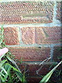
Benchmark on #29 Western Avenue
Ordnance Survey cut mark benchmark described on the Bench Mark Database at http://www.bench-marks.org.uk/bm36906
Image: © Roger Templeman
Taken: 11 Feb 2011
0.02 miles
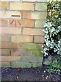
2
Benchmark on #1 Overn Avenue
Ordnance Survey cut mark benchmark described on the Bench Mark Database at http://www.bench-marks.org.uk/bm36905
Image: © Roger Templeman
Taken: 11 Feb 2011
0.11 miles
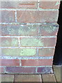
3
Benchmark on #94 Western Avenue
Ordnance Survey cut mark benchmark described on the Bench Mark Database at http://www.bench-marks.org.uk/bm36912
Image: © Roger Templeman
Taken: 11 Feb 2011
0.13 miles
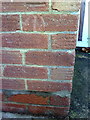
4
Benchmark on the side of #31 Grenville Road
Ordnance Survey cut mark benchmark described on the Bench Mark Database at http://www.bench-marks.org.uk/bm36913
Image: © Roger Templeman
Taken: 11 Feb 2011
0.24 miles
5
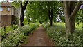
Path running alongside Stowe Avenue
Path running alongside Stowe Avenue at the edge of Buckingham
Image: © Shaun Ferguson
Taken: 7 Jun 2021
0.25 miles
6
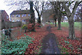
Path by Stowe Avenue
The first houses of Buckingham are on the left.
Image: © Bill Boaden
Taken: 24 Nov 2018
0.25 miles