IMAGES TAKEN NEAR TO
Portfield Way, BUCKINGHAM, MK18 1BB
Introduction
This page details the photographs taken nearby to Portfield Way, MK18 1BB by members of the Geograph project.
The Geograph project started in 2005 with the aim of publishing, organising and preserving representative images for every square kilometre of Great Britain, Ireland and the Isle of Man.

There are currently over 7.5m images from over14,400 individuals and you can help contribute to the project by visiting https://www.geograph.org.uk
Image Map (Loading...)


Getting Data...Please wait
Leaflet Map data © OpenStreetMap
Images are licensed for reuse under creativecommons.org/licenses/by-sa/2.0
Notes
- Clicking on the map will re-center to the selected point.
- The higher the marker number, the further away the image location is from the centre of the postcode.
Image Listing (43 Images Found)
Images are licensed for reuse under creativecommons.org/licenses/by-sa/2.0
Image
Details
Distance
1
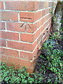
Benchmark on #8 Bourton Road
Ordnance Survey cut mark benchmark described on the Bench Mark Database at http://www.bench-marks.org.uk/bm36883
Image: © Roger Templeman
Taken: 11 Feb 2011
0.09 miles
2

Benchmark on 'Cartref', #42 Bourton Road
Ordnance Survey cut mark benchmark described on the Bench Mark Database at http://www.bench-marks.org.uk/bm36884
Image: © Roger Templeman
Taken: 11 Feb 2011
0.12 miles
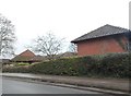
3

Buckingham fire station
Buckingham fire station, Bourton Road, Buckingham, Buckinghamshire
Image: © Kevin Hale
Taken: 24 Nov 2007
0.14 miles
4
Lane in Buckingham
A lane leading from Bridge St, Buckingham to recently developed homes. A knacker's yard occupied the land beyond the posts until relatively recently.
Image: © mick finn
Taken: 11 Oct 2008
0.16 miles
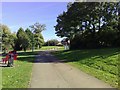
5
Open space along River Great Ouse valley, Buckingham
Image: © Robin Webster
Taken: 27 Mar 2015
0.18 miles
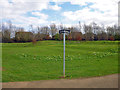
6
Housing complex on London Road, Buckingham
Image: © David Howard
Taken: 4 Feb 2018
0.18 miles
7
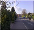
London Road, Buckingham
Looking towards the town along London Road. The New Inn is in the middle distance with the town beyond.
Image: © mick finn
Taken: 13 Apr 2009
0.18 miles
8
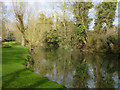
River Great Ouse, Buckingham
By Cornwall's Meadow car park.
Image: © Robin Webster
Taken: 27 Mar 2015
0.18 miles
9
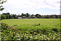
Buckingham cricket ground
Looking across the Great Ouse to the Buckingham cricket ground
Image: © Shaun Ferguson
Taken: 7 Jul 2007
0.19 miles
10
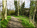
Riverside path, Buckingham
On the town centre side of the River Great Ouse.
Image: © Robin Webster
Taken: 27 Mar 2015
0.19 miles