IMAGES TAKEN NEAR TO
London Road, BUCKINGHAM, MK18 1AR
Introduction
This page details the photographs taken nearby to London Road, MK18 1AR by members of the Geograph project.
The Geograph project started in 2005 with the aim of publishing, organising and preserving representative images for every square kilometre of Great Britain, Ireland and the Isle of Man.

There are currently over 7.5m images from over14,400 individuals and you can help contribute to the project by visiting https://www.geograph.org.uk
Image Map
Images are licensed for reuse under creativecommons.org/licenses/by-sa/2.0
Notes
- Clicking on the map will re-center to the selected point.
- The higher the marker number, the further away the image location is from the centre of the postcode.
Image Listing (22 Images Found)
Images are licensed for reuse under creativecommons.org/licenses/by-sa/2.0
Image
Details
Distance
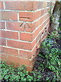
1

Benchmark on Buckingham School
Ordnance Survey cut mark benchmark described on the Bench Mark Database at http://www.bench-marks.org.uk/bm36925
Image: © Roger Templeman
Taken: 17 Feb 2011
0.05 miles
4
Benchmark on #8 Bourton Road
Ordnance Survey cut mark benchmark described on the Bench Mark Database at http://www.bench-marks.org.uk/bm36883
Image: © Roger Templeman
Taken: 11 Feb 2011
0.14 miles
5
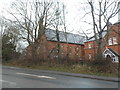
Housing complex on London Road, Buckingham
Image: © David Howard
Taken: 4 Feb 2018
0.17 miles
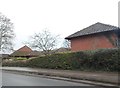
6
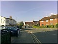
Chandos Road junction with London Road
The junction of Chandos Road and London Road, Buckingham. The Bourton Road turn is marked by the stone buildings in the centre. The car dealership to the left was once a carriage works.
Image: © mick finn
Taken: 13 Apr 2009
0.18 miles
7
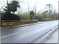
Bridge parapet on London Road in the rain
The footpath sign at the far end of the bridge indicates a bend in the Circular Walk.
Image: © Roger Templeman
Taken: 11 Feb 2011
0.18 miles
8

Benchmark on 'Cartref', #42 Bourton Road
Ordnance Survey cut mark benchmark described on the Bench Mark Database at http://www.bench-marks.org.uk/bm36884
Image: © Roger Templeman
Taken: 11 Feb 2011
0.19 miles
9
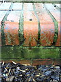
Benchmark on low parapet of bridge on London Road
Ordnance Survey rivet benchmark described on the Bench Mark Database at http://www.bench-marks.org.uk/bm36880
Image: © Roger Templeman
Taken: 11 Feb 2011
0.20 miles
10
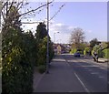
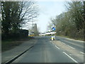
London Road, Buckingham
Looking towards the town along London Road. The New Inn is in the middle distance with the town beyond.
Image: © mick finn
Taken: 13 Apr 2009
0.21 miles