IMAGES TAKEN NEAR TO
Chandos Road, BUCKINGHAM, MK18 1AL
Introduction
This page details the photographs taken nearby to Chandos Road, MK18 1AL by members of the Geograph project.
The Geograph project started in 2005 with the aim of publishing, organising and preserving representative images for every square kilometre of Great Britain, Ireland and the Isle of Man.

There are currently over 7.5m images from over14,400 individuals and you can help contribute to the project by visiting https://www.geograph.org.uk
Image Map
Images are licensed for reuse under creativecommons.org/licenses/by-sa/2.0
Notes
- Clicking on the map will re-center to the selected point.
- The higher the marker number, the further away the image location is from the centre of the postcode.
Image Listing (58 Images Found)
Images are licensed for reuse under creativecommons.org/licenses/by-sa/2.0
Image
Details
Distance
1
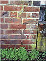
Benchmark on roadside wall of #24 Chandos Road
Ordnance Survey cut mark benchmark described on the Bench Mark Database at http://www.bench-marks.org.uk/bm37039
Image: © Roger Templeman
Taken: 17 Feb 2011
0.01 miles
2
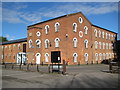
Buckingham: Former Station Mills
On the corner of Station Road, to the left, and Chandos Road, to the right, and opposite the site of the former Image is this building, the former Station Mills corn mill, now the Chandos Road building of The University of Buckingham.
The building is shown on an 1881 Ordnance Survey 1:500 scale map with a railway siding running from the station goods yard via a small turntable through an archway in the building approximately where the reception entrance is on the left now. This turntable also served a longer siding that went across Station Road and down over the River Great Ouse to the Town Mill.
By 1900 the building was shown as a milk factory, so it has had at least three completely different uses in its life. The small extension with the stone date tablet states "1934" while the extension to the left is 20th century too. However the postbox in the wall at the near corner is Victorian.
Image: © Nigel Cox
Taken: 17 Oct 2010
0.04 miles
4
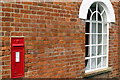
Victorian Postbox on the wall of the University of Buckingham
Image: © Philip Jeffrey
Taken: 13 Jan 2013
0.08 miles
6
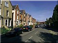
Victorian Villas, Chandos Road
Villas in Chandos Rd, Buckingham built, apparently, to impress Queen Victoria when she visited the town. The road led to the former station. This view is towards the town.
Image: © mick finn
Taken: 11 Oct 2008
0.08 miles
7
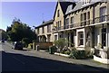
Houses in Chandos Road
Old houses in Chandos Rd, Buckingham. The road leads to what was once the railway station.
Image: © mick finn
Taken: 11 Oct 2008
0.08 miles
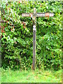
9
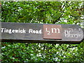
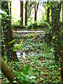
Signpost, Railway Walk, Buckingham
A signpost on railway walk.
Image: © Maddie Hooper
Taken: 5 Oct 2008
0.08 miles
10
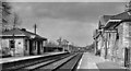
Buckingham Station
View NW, towards Banbury; ex-London & North Western, Bletchley - Verney Junction - Banbury line. Buckingham - Banbury was closed 2/1/61 and the station closed to passengers on 7/9/64, but the line from Verney Junction was not finally closed until 5/12/66. It looks healthy enough, if deserted, in this 1962 picture. Evidently the platforms were rather low, as moveable steps can be seen on the right.
Image: © Ben Brooksbank
Taken: 24 Mar 1962
0.08 miles