IMAGES TAKEN NEAR TO
Woburn Park, MILTON KEYNES, MK17 9QN
Introduction
This page details the photographs taken nearby to Woburn Park, MK17 9QN by members of the Geograph project.
The Geograph project started in 2005 with the aim of publishing, organising and preserving representative images for every square kilometre of Great Britain, Ireland and the Isle of Man.

There are currently over 7.5m images from over14,400 individuals and you can help contribute to the project by visiting https://www.geograph.org.uk
Image Map
Images are licensed for reuse under creativecommons.org/licenses/by-sa/2.0
Notes
- Clicking on the map will re-center to the selected point.
- The higher the marker number, the further away the image location is from the centre of the postcode.
Image Listing (7 Images Found)
Images are licensed for reuse under creativecommons.org/licenses/by-sa/2.0
Image
Details
Distance
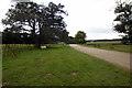
1
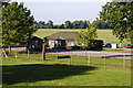
Crawleyheath Farm at Woburn Safari Park
Looking northwest along track.
Image: © Peter Wood
Taken: 29 Nov 2012
0.02 miles
2
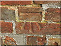
Ordnance Survey Cut Mark
This mark can be found on the wall of a building at Crawleyheath Farm.
For more detail see : http://www.bench-marks.org.uk/bm46482
Image: © Peter Wood
Taken: 29 Nov 2012
0.02 miles
3
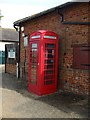
Telephone box
Disappointed that it doesn't have leather hinges
Image: © Barry Ephgrave
Taken: 9 May 2009
0.04 miles
4
Entrance to Woburn Safari Park
Taken on a very hot October day 2011. This is from the wooden bridge leading back towards the deer park.
Image: © Barry Ephgrave
Taken: 2 Oct 2011
0.06 miles
5
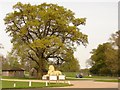
Lion at Woburn Safari Park
Ok he's not a real lion, but he is rather grand nevertheless. One of two greeting the visitor to the safari park.
Image: © Ian Paterson
Taken: 23 Apr 2009
0.10 miles
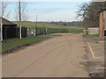
6
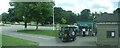
Coach Office, Woburn Safari Park
Looking north-east
Image: © Kenneth Allen
Taken: 1 Aug 2008
0.11 miles