IMAGES TAKEN NEAR TO
Russwell Lane, MILTON KEYNES, MK17 9NN
Introduction
This page details the photographs taken nearby to Russwell Lane, MK17 9NN by members of the Geograph project.
The Geograph project started in 2005 with the aim of publishing, organising and preserving representative images for every square kilometre of Great Britain, Ireland and the Isle of Man.

There are currently over 7.5m images from over14,400 individuals and you can help contribute to the project by visiting https://www.geograph.org.uk
Image Map (Loading...)


Getting Data...Please wait
Leaflet Map data © OpenStreetMap
Images are licensed for reuse under creativecommons.org/licenses/by-sa/2.0
Notes
- Clicking on the map will re-center to the selected point.
- The higher the marker number, the further away the image location is from the centre of the postcode.
Image Listing (9 Images Found)
Images are licensed for reuse under creativecommons.org/licenses/by-sa/2.0
Image
Details
Distance
1
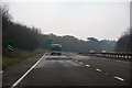
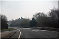
Borough of Milton Keynes : The A5
Heading along the A5 road.
Image: © Lewis Clarke
Taken: 25 Mar 2018
0.20 miles
2
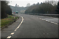
Borough of Milton Keynes : The A5
The section of the A5 between London and Shrewsbury is roughly contiguous with one of the principal Roman roads in Britain: that between Londinium and Deva.
Image: © Lewis Clarke
Taken: 25 Mar 2018
0.21 miles
3
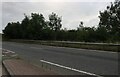
The A5, Little Brickhill
The layby goes through three map squares, this end projects beyond the first two.
Image: © David Howard
Taken: 22 Aug 2021
0.22 miles
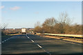
5
Borough of Milton Keynes : The A5
Looking along the A5 as it heads through Buckinghamshire.
Image: © Lewis Clarke
Taken: 25 Mar 2018
0.23 miles
6
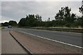
Layby on the A5, Little Brickhill
A previous visit https://www.geograph.org.uk/photo/6559656
Image: © David Howard
Taken: 22 Aug 2021
0.23 miles
7
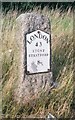
Old Milestone by the A5, west of Little Brickhill
Metal plate attached to stone post by the A5, in parish of Little Brickhill (Milton Keynes District), South-bound carriageway, in lay-by West of Glebe Farm, 400m East of roundabout, on cut grass verge between lay-by and hedge, on North side of road. Milton Keynes alloy plate (New), erected by the Holyhead Road (Hockliffe Division) turnpike trust in the 20th century.
Inscription reads:-
LONDON
43
STONY
STRATFORD
8
Milestone Society National ID: BU_LH43
Image: © A Rosevear
Taken: 11 Jul 2003
0.24 miles
8
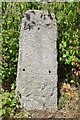
Old Milestone by the A5, Little Brickhill
Stone post (plate lost) by the A5, in parish of Little Brickhill (Milton Keynes District), south-bound carriageway, in lay-by West of Glebe Farm, 400m East of roundabout, on cut grass verge between lay-by and hedge, on North side of road. Milton Keynes stone, erected by the Holyhead Road (Hockliffe Div) Turnpike Trust in the 20th century.
Inscription once read:-
(London)
(43)
(Stony Stratford)
(8)
Milestone Society National ID: BU_LH43.
Image: © Milestone Society
Taken: 22 Jun 2018
0.24 miles
9
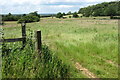
Footpath across the field to Back Wood
Image: © Philip Jeffrey
Taken: 30 Jun 2012
0.25 miles