IMAGES TAKEN NEAR TO
Little Brickhill, MILTON KEYNES, MK17 9LJ
Introduction
This page details the photographs taken nearby to MK17 9LJ by members of the Geograph project.
The Geograph project started in 2005 with the aim of publishing, organising and preserving representative images for every square kilometre of Great Britain, Ireland and the Isle of Man.

There are currently over 7.5m images from over14,400 individuals and you can help contribute to the project by visiting https://www.geograph.org.uk
Image Map
Images are licensed for reuse under creativecommons.org/licenses/by-sa/2.0
Notes
- Clicking on the map will re-center to the selected point.
- The higher the marker number, the further away the image location is from the centre of the postcode.
Image Listing (7 Images Found)
Images are licensed for reuse under creativecommons.org/licenses/by-sa/2.0
Image
Details
Distance
1
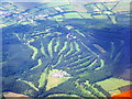
Woburn Golf Club
An aerial view from above the A5 near Heath and Reach.
Image: © M J Richardson
Taken: 26 Jun 2015
0.04 miles
2
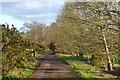
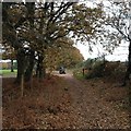
Track, Little Brickhill
A bridleway crossing the south-western part of Woburn Golf Club.
Image: © Andrew Smith
Taken: 30 Mar 2024
0.07 miles
3
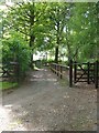
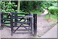
Public Footpath, Woburn GC
A footpath that runs onto the Woburn Golf Club.
Image: © Mr Biz
Taken: 20 May 2008
0.11 miles
5

Woburn - Marquess' Course
Approaching the green at the 12th hole
Image: © Andrew F Shinie
Taken: 12 Jul 2007
0.15 miles
7
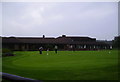
Woburn Golf Club
Club house and practice putting green
Image: © Anthony Warren
Taken: 27 Sep 2006
0.24 miles