IMAGES TAKEN NEAR TO
Church Road, MILTON KEYNES, MK17 9LH
Introduction
This page details the photographs taken nearby to Church Road, MK17 9LH by members of the Geograph project.
The Geograph project started in 2005 with the aim of publishing, organising and preserving representative images for every square kilometre of Great Britain, Ireland and the Isle of Man.

There are currently over 7.5m images from over14,400 individuals and you can help contribute to the project by visiting https://www.geograph.org.uk
Image Map
Images are licensed for reuse under creativecommons.org/licenses/by-sa/2.0
Notes
- Clicking on the map will re-center to the selected point.
- The higher the marker number, the further away the image location is from the centre of the postcode.
Image Listing (48 Images Found)
Images are licensed for reuse under creativecommons.org/licenses/by-sa/2.0
Image
Details
Distance
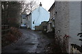
1

Church Road, Bow Brickhill
Cottages on the steep descent from the church at the eastern end of the village.
Image: © Andrew Smith
Taken: 10 Jul 2009
0.01 miles
2
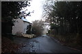
Down Church Road, Bow Brickhill
Looking back towards the Green
Image: © Robert Eva
Taken: 20 Dec 2016
0.03 miles

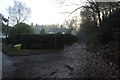
6
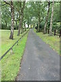
Drive which is also a public footpath
It runs off Church Lane.
Image: © Basher Eyre
Taken: 6 Sep 2011
0.08 miles
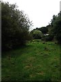
8
Footpath to All Saints Church, Bow Brickhill
The path is a short cut from Church Road.
Image: © Robert Eva
Taken: 20 Dec 2016
0.09 miles
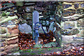
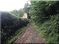
10

War Memorial, Bow Brickhill
And some festive decoration on the tree behind.
Image: © Robert Eva
Taken: 20 Dec 2016
0.09 miles