IMAGES TAKEN NEAR TO
Newport Road, MILTON KEYNES, MK17 9HX
Introduction
This page details the photographs taken nearby to Newport Road, MK17 9HX by members of the Geograph project.
The Geograph project started in 2005 with the aim of publishing, organising and preserving representative images for every square kilometre of Great Britain, Ireland and the Isle of Man.

There are currently over 7.5m images from over14,400 individuals and you can help contribute to the project by visiting https://www.geograph.org.uk
Image Map
Images are licensed for reuse under creativecommons.org/licenses/by-sa/2.0
Notes
- Clicking on the map will re-center to the selected point.
- The higher the marker number, the further away the image location is from the centre of the postcode.
Image Listing (6 Images Found)
Images are licensed for reuse under creativecommons.org/licenses/by-sa/2.0
Image
Details
Distance
1
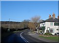
The Birch Pub, Woburn
On the main road between Woburn and Woburn Sands. It is missing its sign at the time of taking.
Image: © Bikeboy
Taken: 16 Feb 2014
0.10 miles

4
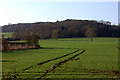
Tracks across the field
Near Birchmoor Farm
Image: © Robert Eva
Taken: 20 Dec 2016
0.17 miles
5
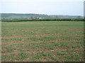
From the public footpath (4)
Looking towards Dolton's Farm in the distance. This is the last of 4 views from the same point. For the first, see Image
Image: © Ian Paterson
Taken: 23 Apr 2009
0.18 miles
6
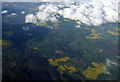
Woburn Park from the air
Viewed from a Glasgow bound flight from Luton.
Image: © Thomas Nugent
Taken: 11 May 2012
0.22 miles