IMAGES TAKEN NEAR TO
Kitchener Drive, MILTON KEYNES, MK17 9GF
Introduction
This page details the photographs taken nearby to Kitchener Drive, MK17 9GF by members of the Geograph project.
The Geograph project started in 2005 with the aim of publishing, organising and preserving representative images for every square kilometre of Great Britain, Ireland and the Isle of Man.

There are currently over 7.5m images from over14,400 individuals and you can help contribute to the project by visiting https://www.geograph.org.uk
Image Map
Images are licensed for reuse under creativecommons.org/licenses/by-sa/2.0
Notes
- Clicking on the map will re-center to the selected point.
- The higher the marker number, the further away the image location is from the centre of the postcode.
Image Listing (8 Images Found)
Images are licensed for reuse under creativecommons.org/licenses/by-sa/2.0
Image
Details
Distance
1
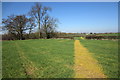
Path across the fields to Fenny Stratford
Image: © Philip Jeffrey
Taken: 26 Mar 2012
0.02 miles
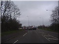
2
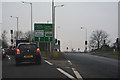
Milton Keynes : The A4146
A roundabout on the A4146.
Image: © Lewis Clarke
Taken: 24 Mar 2018
0.20 miles
3
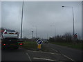
Roundabout on Watling Street, Fenny Stratford
Image: © David Howard
Taken: 4 Apr 2012
0.22 miles
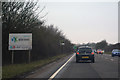
4
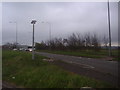
Watling Street approaching the roundabout
Image: © David Howard
Taken: 4 Apr 2012
0.22 miles
5
Approaching the roundabout at the end of Watling Street
Image: © David Howard
Taken: 4 Apr 2012
0.22 miles
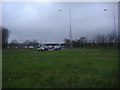
6
Milton Keynes : The A4146
A road heading into the town of Milton Keynes.
Image: © Lewis Clarke
Taken: 24 Mar 2018
0.23 miles
7
Grass lane divider on the A5 roundabout Fenny Stratford
Image: © David Howard
Taken: 4 Apr 2012
0.24 miles
8
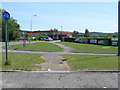
Petrol Station
At the Little Brickhill roundabout on the A5 Watling Street.
Image: © Cameraman
Taken: 22 Jun 2010
0.24 miles