IMAGES TAKEN NEAR TO
Berry End, MILTON KEYNES, MK17 9EB
Introduction
This page details the photographs taken nearby to Berry End, MK17 9EB by members of the Geograph project.
The Geograph project started in 2005 with the aim of publishing, organising and preserving representative images for every square kilometre of Great Britain, Ireland and the Isle of Man.

There are currently over 7.5m images from over14,400 individuals and you can help contribute to the project by visiting https://www.geograph.org.uk
Image Map
Images are licensed for reuse under creativecommons.org/licenses/by-sa/2.0
Notes
- Clicking on the map will re-center to the selected point.
- The higher the marker number, the further away the image location is from the centre of the postcode.
Image Listing (8 Images Found)
Images are licensed for reuse under creativecommons.org/licenses/by-sa/2.0
Image
Details
Distance
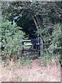
3
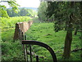
Berryedge plantation and Woburn estate wall
Towards Eversholt - Purretts Hill in distance
Image: © ian saunders
Taken: 17 May 2007
0.20 miles
5
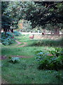
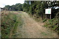
Path through the Berryend Plantation with deer
Image: © Philip Jeffrey
Taken: 19 Sep 2012
0.23 miles
6
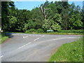
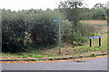
Road Junction, Eversholt
From the main Woburn - Eversholt road, this junction follows off south towards the Tyrells End area of Eversholt.
Image: © Mr Biz
Taken: 8 Jun 2008
0.24 miles
7
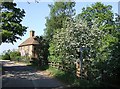
Berry End Farm, Higher Berry End
This is one of the very few buildings on the quiet lane between Ridgmont and Eversholt.
Image: © Rob Farrow
Taken: 2 May 2007
0.24 miles