IMAGES TAKEN NEAR TO
Witts End, MILTON KEYNES, MK17 9DY
Introduction
This page details the photographs taken nearby to Witts End, MK17 9DY by members of the Geograph project.
The Geograph project started in 2005 with the aim of publishing, organising and preserving representative images for every square kilometre of Great Britain, Ireland and the Isle of Man.

There are currently over 7.5m images from over14,400 individuals and you can help contribute to the project by visiting https://www.geograph.org.uk
Image Map
Images are licensed for reuse under creativecommons.org/licenses/by-sa/2.0
Notes
- Clicking on the map will re-center to the selected point.
- The higher the marker number, the further away the image location is from the centre of the postcode.
Image Listing (8 Images Found)
Images are licensed for reuse under creativecommons.org/licenses/by-sa/2.0
Image
Details
Distance
1
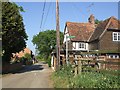
No-Through-Road, Higher Rads End
Taken from its junction with the lane through Higher and Lower Rads End, this is the view up the No-through-road that leads to Image]
Image: © Rob Farrow
Taken: 2 May 2007
0.17 miles
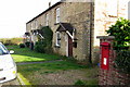
3
Higher Rads End - Houses
A view back along the Image] from near its dead-end. The footpath signposted to the right heads roughly southwards across fields towards Castle Farm.
Image: © Rob Farrow
Taken: 2 May 2007
0.18 miles
5
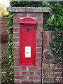
Victorian Post Box set in a brick pillar
Image: © Philip Jeffrey
Taken: 13 Nov 2012
0.20 miles
6
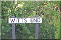
Witts End
Kids drove me to it.
Round Eversholt there are a series of "Ends" - Tyrells End, Rads End etc.
Image: © Dennis simpson
Taken: 12 May 2006
0.22 miles