IMAGES TAKEN NEAR TO
Baker Grove, MILTON KEYNES, MK17 8WS
Introduction
This page details the photographs taken nearby to Baker Grove, MK17 8WS by members of the Geograph project.
The Geograph project started in 2005 with the aim of publishing, organising and preserving representative images for every square kilometre of Great Britain, Ireland and the Isle of Man.

There are currently over 7.5m images from over14,400 individuals and you can help contribute to the project by visiting https://www.geograph.org.uk
Image Map
Images are licensed for reuse under creativecommons.org/licenses/by-sa/2.0
Notes
- Clicking on the map will re-center to the selected point.
- The higher the marker number, the further away the image location is from the centre of the postcode.
Image Listing (12 Images Found)
Images are licensed for reuse under creativecommons.org/licenses/by-sa/2.0
Image
Details
Distance
1
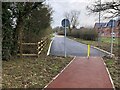
Stockwell Lane has become a footpath here
Image: © Philip Jeffrey
Taken: 21 Feb 2021
0.11 miles
3
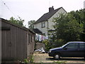
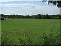
Glebe Farm House
A view from the farm yard at the rear of the house.
Image: © Mr Biz
Taken: 26 Jul 2006
0.12 miles
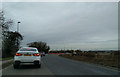
4
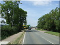
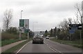
Newport Road (A5130)
Heading north west near Glebe Farm.
Image: © JThomas
Taken: 22 Aug 2015
0.13 miles
6
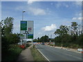
Approaching roundabout on Newport Road (A5130)
Heading north west.
Image: © JThomas
Taken: 22 Aug 2015
0.18 miles
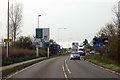
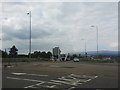
9

Roundabout on Newport Road, Wavendon
The stripy blue warehouses are cropping up all around the south Midlands, maybe they are all made by the same company.
Image: © David Howard
Taken: 20 Sep 2020
0.21 miles