IMAGES TAKEN NEAR TO
Parkway, MILTON KEYNES, MK17 8UH
Introduction
This page details the photographs taken nearby to Parkway, MK17 8UH by members of the Geograph project.
The Geograph project started in 2005 with the aim of publishing, organising and preserving representative images for every square kilometre of Great Britain, Ireland and the Isle of Man.

There are currently over 7.5m images from over14,400 individuals and you can help contribute to the project by visiting https://www.geograph.org.uk
Image Map
Images are licensed for reuse under creativecommons.org/licenses/by-sa/2.0
Notes
- Clicking on the map will re-center to the selected point.
- The higher the marker number, the further away the image location is from the centre of the postcode.
Image Listing (15 Images Found)
Images are licensed for reuse under creativecommons.org/licenses/by-sa/2.0
Image
Details
Distance
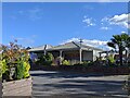
4
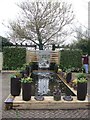
Entrance to garden centre, Woburn Sands
The road leading into Wyevale Garden Centre off Newport Road, passing between bungalows.
Image: © Derek Harper
Taken: 5 Feb 2011
0.13 miles
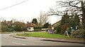
5

Car wash in the car park of Woburn Sands Emporium garden centre
Image: © Rob Purvis
Taken: 22 Oct 2023
0.14 miles


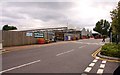
10
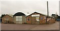
Frosts Landscape Construction, Woburn Sands
Some of the buildings at the landscape construction part of Frost's, seen from Newport Road.
Image: © Derek Harper
Taken: 5 Feb 2011
0.18 miles