IMAGES TAKEN NEAR TO
Elm Grove, MILTON KEYNES, MK17 8PS
Introduction
This page details the photographs taken nearby to Elm Grove, MK17 8PS by members of the Geograph project.
The Geograph project started in 2005 with the aim of publishing, organising and preserving representative images for every square kilometre of Great Britain, Ireland and the Isle of Man.

There are currently over 7.5m images from over14,400 individuals and you can help contribute to the project by visiting https://www.geograph.org.uk
Image Map
Images are licensed for reuse under creativecommons.org/licenses/by-sa/2.0
Notes
- Clicking on the map will re-center to the selected point.
- The higher the marker number, the further away the image location is from the centre of the postcode.
Image Listing (21 Images Found)
Images are licensed for reuse under creativecommons.org/licenses/by-sa/2.0
Image
Details
Distance
2
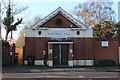
Ellen Pettit Memorial Hall, Woburn Sands
Built in 1928 by Mr A Pettit in memory of his wife Ellen, it was originally St Michael's church hall.
Image: © Robert Eva
Taken: 20 Dec 2016
0.15 miles
3
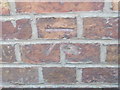
Ordnance Survey Cut Mark
This mark can be found on the wall of a house in Station Road.
For more detail see : http://www.bench-marks.org.uk/bm46485
Image: © Peter Wood
Taken: 29 Nov 2012
0.17 miles
4
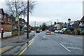
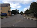
Station Road, Woburn Sands
Towards the station, which is on the Bletchley - Bedford line.
Image: © Robin Webster
Taken: 5 Dec 2021
0.18 miles
5
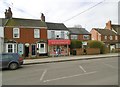
Woburn Sands Convenience Store
On Station Road (A5130).
Image: © Mike Faherty
Taken: 17 Feb 2017
0.18 miles