IMAGES TAKEN NEAR TO
Mount Pleasant, MILTON KEYNES, MK17 8JZ
Introduction
This page details the photographs taken nearby to Mount Pleasant, MK17 8JZ by members of the Geograph project.
The Geograph project started in 2005 with the aim of publishing, organising and preserving representative images for every square kilometre of Great Britain, Ireland and the Isle of Man.

There are currently over 7.5m images from over14,400 individuals and you can help contribute to the project by visiting https://www.geograph.org.uk
Image Map
Images are licensed for reuse under creativecommons.org/licenses/by-sa/2.0
Notes
- Clicking on the map will re-center to the selected point.
- The higher the marker number, the further away the image location is from the centre of the postcode.
Image Listing (7 Images Found)
Images are licensed for reuse under creativecommons.org/licenses/by-sa/2.0
Image
Details
Distance
1
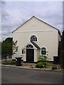
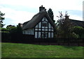
The Old Chapel, Aspley Guise
Another converted chapel that's now used as a home, located on Horsepool Lane.
Image: © Mr Biz
Taken: 11 Aug 2006
0.05 miles
2
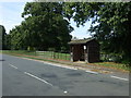
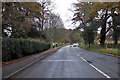
Bus stop and shelter on Bedford Road, Aspley Guise
Image: © JThomas
Taken: 22 Aug 2015
0.12 miles
3
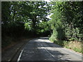
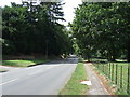
Bedford Road, Aspley Guise
Heading south west.
Image: © JThomas
Taken: 22 Aug 2015
0.13 miles