IMAGES TAKEN NEAR TO
Woburn Lane, MILTON KEYNES, MK17 8JN
Introduction
This page details the photographs taken nearby to Woburn Lane, MK17 8JN by members of the Geograph project.
The Geograph project started in 2005 with the aim of publishing, organising and preserving representative images for every square kilometre of Great Britain, Ireland and the Isle of Man.

There are currently over 7.5m images from over14,400 individuals and you can help contribute to the project by visiting https://www.geograph.org.uk
Image Map
Images are licensed for reuse under creativecommons.org/licenses/by-sa/2.0
Notes
- Clicking on the map will re-center to the selected point.
- The higher the marker number, the further away the image location is from the centre of the postcode.
Image Listing (23 Images Found)
Images are licensed for reuse under creativecommons.org/licenses/by-sa/2.0
Image
Details
Distance
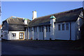
5
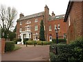
Moore Place, Aspley Guise
The hotel, built in about 1786, is listed as "The Holt" http://www.britishlistedbuildings.co.uk/en-38120-the-holt-aspley-guise , but has now reverted to its original name. The facade boasts three Venetian windows and a Diocletian window.
Image: © Derek Harper
Taken: 5 Feb 2011
0.09 miles
6
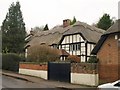
Easter Cottage, Aspley Guise
As http://www.britishlistedbuildings.co.uk/en-38127-easter-cottage-18-aspley-guise explains, this C16 thatched cottage was formerly The Steamer public house.
Image: © Derek Harper
Taken: 5 Feb 2011
0.09 miles
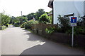
7
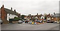
The Square, Aspley Guise
On a depressingly gloomy day, and about to get more depressing. I'd timed my arrival here to catch a bus to the station in Milton Keynes in time for a given train. However, because Bedford Road is closed for roadworks, the bus is diverted, and doesn't even come through Aspley Guise. All is not lost, because a notice attached to the bus stop tells me that a free taxi service is available as a replacement to Woburn Sands. So I ring the number, to be told by the taxi company that they're too busy to bother with me. I fervently hope that the local authority or the bus company weren't paying the taxi company anything for this non-existent service. So there followed an unscheduled walk/dash of over four kilometres to Old Farm Park to pick up another bus service. Miraculously, I still made the train.
Image: © Derek Harper
Taken: 5 Feb 2011
0.09 miles
8
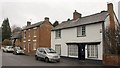
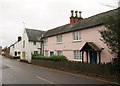
Cottages in Aspley Guise
Cottages on West Hill a little southwest of The Square. The right-hand building is an "early C19 reworking of {an} earlier structure" http://www.britishlistedbuildings.co.uk/en-38125-10-aspley-guise .
Image: © Derek Harper
Taken: 5 Feb 2011
0.09 miles
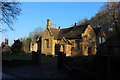
9
The Lodge, Aspley Guise
A "complex plan" for this early C19 house on West Hill, with ornamental glazing bars and decorative chimney pots http://www.britishlistedbuildings.co.uk/en-38126-the-lodge-aspley-guise .
Image: © Derek Harper
Taken: 5 Feb 2011
0.09 miles
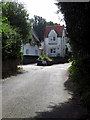
10
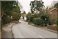
West Hill, Aspley Guise
The road from Woburn Sands drops steadily towards the village centre, visible in the distance.
Image: © Derek Harper
Taken: 5 Feb 2011
0.10 miles