IMAGES TAKEN NEAR TO
Mill Way, MILTON KEYNES, MK17 8HR
Introduction
This page details the photographs taken nearby to Mill Way, MK17 8HR by members of the Geograph project.
The Geograph project started in 2005 with the aim of publishing, organising and preserving representative images for every square kilometre of Great Britain, Ireland and the Isle of Man.

There are currently over 7.5m images from over14,400 individuals and you can help contribute to the project by visiting https://www.geograph.org.uk
Image Map
Images are licensed for reuse under creativecommons.org/licenses/by-sa/2.0
Notes
- Clicking on the map will re-center to the selected point.
- The higher the marker number, the further away the image location is from the centre of the postcode.
Image Listing (5 Images Found)
Images are licensed for reuse under creativecommons.org/licenses/by-sa/2.0
Image
Details
Distance
1
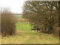
Edge of golf course, Aspley Guise
Looking from the footpath between Common Farm and St Botolph's church along the eastern edge of Aspley Guise & Woburn Sands Golf Club.
Image: © Derek Harper
Taken: 5 Feb 2011
0.09 miles
2
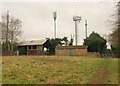
Masts at Common Farm
An assortment of telecommunication masts on the relatively high ground between Aspley Guise and Woburn Sands.
Image: © Derek Harper
Taken: 5 Feb 2011
0.15 miles
3
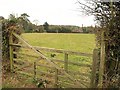
Field near Aspley Guise
Looking past a gate on a field path connecting the track shown in Image to West Hill.
Image: © Derek Harper
Taken: 5 Feb 2011
0.21 miles
4
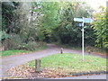
Footpath sign, Aspley Guise
A public footpath sign at Aspley Guise, Bedfordshire. The path in the image leads to the neighbouring village of Woburn Sands.
Image: © Malc McDonald
Taken: 20 Oct 2012
0.24 miles
5
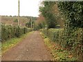
Track past Aspley Guise Recreation Ground
Carrying the footpath from Common Farm towards West Hill. The Recreation Ground is on the right.
Image: © Derek Harper
Taken: 5 Feb 2011
0.25 miles