IMAGES TAKEN NEAR TO
Hayfield Business Park, MILTON KEYNES, MK17 8HL
Introduction
This page details the photographs taken nearby to Hayfield Business Park, MK17 8HL by members of the Geograph project.
The Geograph project started in 2005 with the aim of publishing, organising and preserving representative images for every square kilometre of Great Britain, Ireland and the Isle of Man.

There are currently over 7.5m images from over14,400 individuals and you can help contribute to the project by visiting https://www.geograph.org.uk
Image Map
Images are licensed for reuse under creativecommons.org/licenses/by-sa/2.0
Notes
- Clicking on the map will re-center to the selected point.
- The higher the marker number, the further away the image location is from the centre of the postcode.
Image Listing (9 Images Found)
Images are licensed for reuse under creativecommons.org/licenses/by-sa/2.0
Image
Details
Distance
2
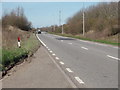
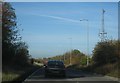
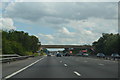
A421
The A421 runs parallel to the M1 for over a mile west-northwest of J13. This is an accident blackspot with some drivers having come off the motorway forgetting that this is a two way road.
Image: © Richard Schmidt
Taken: 16 Mar 2007
0.20 miles
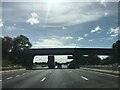
4
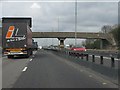
M1 motorway - Brook Farm accommodation bridge
Image: © Peter Whatley
Taken: 3 Apr 2012
0.21 miles
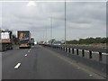
6
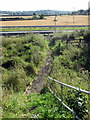
Footbridge over the M1
Not much used by the look of it
Image: © Philip Jeffrey
Taken: 3 Sep 2012
0.22 miles
9
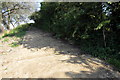
Ramp up to the footbridge over the M1
Image: © Philip Jeffrey
Taken: 3 Sep 2012
0.24 miles