IMAGES TAKEN NEAR TO
Woodside, MILTON KEYNES, MK17 8EH
Introduction
This page details the photographs taken nearby to Woodside, MK17 8EH by members of the Geograph project.
The Geograph project started in 2005 with the aim of publishing, organising and preserving representative images for every square kilometre of Great Britain, Ireland and the Isle of Man.

There are currently over 7.5m images from over14,400 individuals and you can help contribute to the project by visiting https://www.geograph.org.uk
Image Map
Images are licensed for reuse under creativecommons.org/licenses/by-sa/2.0
Notes
- Clicking on the map will re-center to the selected point.
- The higher the marker number, the further away the image location is from the centre of the postcode.
Image Listing (8 Images Found)
Images are licensed for reuse under creativecommons.org/licenses/by-sa/2.0
Image
Details
Distance
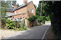
2
West Hill, Aspley Guise
Looking south west.
Image: © JThomas
Taken: 22 Aug 2015
0.15 miles
4
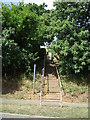
Footpath up a bank, Aspley Guise
Off West Hill.
Image: © JThomas
Taken: 22 Aug 2015
0.17 miles
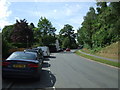
6
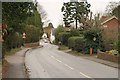
West Hill, Aspley Guise
The road from Woburn Sands drops steadily towards the village centre, visible in the distance.
Image: © Derek Harper
Taken: 5 Feb 2011
0.24 miles
7
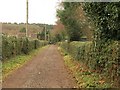
Track past Aspley Guise Recreation Ground
Carrying the footpath from Common Farm towards West Hill. The Recreation Ground is on the right.
Image: © Derek Harper
Taken: 5 Feb 2011
0.24 miles
8
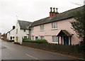
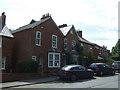
The Lodge, Aspley Guise
A "complex plan" for this early C19 house on West Hill, with ornamental glazing bars and decorative chimney pots http://www.britishlistedbuildings.co.uk/en-38126-the-lodge-aspley-guise .
Image: © Derek Harper
Taken: 5 Feb 2011
0.25 miles