IMAGES TAKEN NEAR TO
West Hill, MILTON KEYNES, MK17 8DU
Introduction
This page details the photographs taken nearby to West Hill, MK17 8DU by members of the Geograph project.
The Geograph project started in 2005 with the aim of publishing, organising and preserving representative images for every square kilometre of Great Britain, Ireland and the Isle of Man.

There are currently over 7.5m images from over14,400 individuals and you can help contribute to the project by visiting https://www.geograph.org.uk
Image Map
Images are licensed for reuse under creativecommons.org/licenses/by-sa/2.0
Notes
- Clicking on the map will re-center to the selected point.
- The higher the marker number, the further away the image location is from the centre of the postcode.
Image Listing (7 Images Found)
Images are licensed for reuse under creativecommons.org/licenses/by-sa/2.0
Image
Details
Distance
1
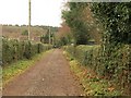
Track past Aspley Guise Recreation Ground
Carrying the footpath from Common Farm towards West Hill. The Recreation Ground is on the right.
Image: © Derek Harper
Taken: 5 Feb 2011
0.09 miles
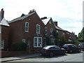
2
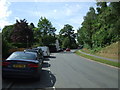
Junction of Aspley Hill and Weathercock Lane
This is on the edge of Woburn Sands.
Image: © Robert Eva
Taken: 20 Dec 2016
0.14 miles
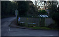
3
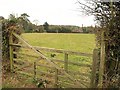
Field near Aspley Guise
Looking past a gate on a field path connecting the track shown in Image to West Hill.
Image: © Derek Harper
Taken: 5 Feb 2011
0.15 miles
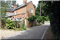
4
West Hill, Aspley Guise
Looking south west.
Image: © JThomas
Taken: 22 Aug 2015
0.19 miles
5
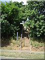
Footpath up a bank, Aspley Guise
Off West Hill.
Image: © JThomas
Taken: 22 Aug 2015
0.20 miles