IMAGES TAKEN NEAR TO
Salford Road, MILTON KEYNES, MK17 8BS
Introduction
This page details the photographs taken nearby to Salford Road, MK17 8BS by members of the Geograph project.
The Geograph project started in 2005 with the aim of publishing, organising and preserving representative images for every square kilometre of Great Britain, Ireland and the Isle of Man.

There are currently over 7.5m images from over14,400 individuals and you can help contribute to the project by visiting https://www.geograph.org.uk
Image Map
Images are licensed for reuse under creativecommons.org/licenses/by-sa/2.0
Notes
- Clicking on the map will re-center to the selected point.
- The higher the marker number, the further away the image location is from the centre of the postcode.
Image Listing (14 Images Found)
Images are licensed for reuse under creativecommons.org/licenses/by-sa/2.0
Image
Details
Distance
1
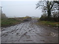
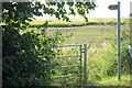
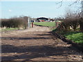
Yard Entrance
An entrance to what appears to be part of the Hulcote Farm estate.
Image: © Mr Biz
Taken: 20 Nov 2010
0.06 miles
2
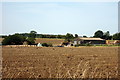
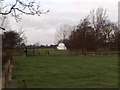
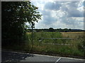
Hulcote Farm
The farmhouse at Hulcote Farm, visible through the leafless trees of winter.
Image: © Richard Schmidt
Taken: 16 Mar 2007
0.06 miles
4
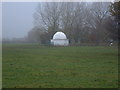
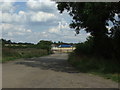
Observatory
A small observatory at Hulcote Farm, Salford Road.
Image: © Mr Biz
Taken: 20 Nov 2010
0.09 miles
5
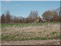
Observatory
This looks like an amateur astronomer's private observatory
Image: © David M Jones
Taken: 28 Dec 2007
0.10 miles
9
Out-buildings
Out-buildings at Hulcote Farm.
Image: © Richard Schmidt
Taken: 16 Mar 2007
0.12 miles