IMAGES TAKEN NEAR TO
Mill Lane, MILTON KEYNES, MK17 8BP
Introduction
This page details the photographs taken nearby to Mill Lane, MK17 8BP by members of the Geograph project.
The Geograph project started in 2005 with the aim of publishing, organising and preserving representative images for every square kilometre of Great Britain, Ireland and the Isle of Man.

There are currently over 7.5m images from over14,400 individuals and you can help contribute to the project by visiting https://www.geograph.org.uk
Image Map
Images are licensed for reuse under creativecommons.org/licenses/by-sa/2.0
Notes
- Clicking on the map will re-center to the selected point.
- The higher the marker number, the further away the image location is from the centre of the postcode.
Image Listing (10 Images Found)
Images are licensed for reuse under creativecommons.org/licenses/by-sa/2.0
Image
Details
Distance
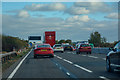
1
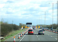
Roadworks on M1 near Hulcote
Heading south east towards London.
Image: © JThomas
Taken: 5 Mar 2012
0.14 miles
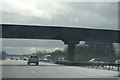
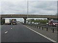
2
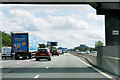
Southbound M1
View from below the footbridge near Aspley Hall.
Image: © David Dixon
Taken: 11 Aug 2023
0.15 miles
3
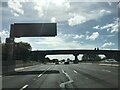
Central Bedfordshire : M1 Motorway
The M1 Motorway between Junction 14 (Broughton) and Junction 13 (Ridgmont).
Image: © Lewis Clarke
Taken: 3 Oct 2018
0.15 miles

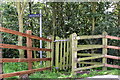
8
Aspley Hall accommodation bridge, M1 motorway
Image: © Peter Whatley
Taken: 3 Apr 2012
0.20 miles