IMAGES TAKEN NEAR TO
Wafandun Lane, MILTON KEYNES, MK17 7AA
Introduction
This page details the photographs taken nearby to Wafandun Lane, MK17 7AA by members of the Geograph project.
The Geograph project started in 2005 with the aim of publishing, organising and preserving representative images for every square kilometre of Great Britain, Ireland and the Isle of Man.

There are currently over 7.5m images from over14,400 individuals and you can help contribute to the project by visiting https://www.geograph.org.uk
Image Map
Images are licensed for reuse under creativecommons.org/licenses/by-sa/2.0
Notes
- Clicking on the map will re-center to the selected point.
- The higher the marker number, the further away the image location is from the centre of the postcode.
Image Listing (11 Images Found)
Images are licensed for reuse under creativecommons.org/licenses/by-sa/2.0
Image
Details
Distance
1
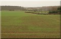
Farmland near Lower End
A young crop seen Lower End Road. Fox Covert is the wood on the left. Traffic can be seen on the M1 at upper right.
Image: © Derek Harper
Taken: 5 Feb 2011
0.03 miles
2
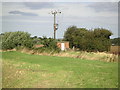
Rural Substation
Small substation and pylon located just outside of Wavendon on the other side of the golf course.
Image: © Mr Biz
Taken: 4 Sep 2006
0.14 miles
5
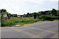
Building plot
The existing house has made way for an "executive style home" here
Image: © Philip Jeffrey
Taken: 28 Jun 2012
0.18 miles
6
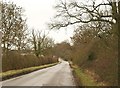
Lower End Road
The road links Wavendon to Salford. Here it dips across a shallow valley as it passes Lodge Farm.
Image: © Derek Harper
Taken: 5 Feb 2011
0.20 miles
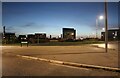
8

Eagle Farm Roundabout, Wavendon
From Burney Drive, looking towards the H&M warehouse.
Image: © David Howard
Taken: 30 Oct 2022
0.21 miles
9
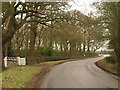
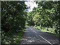
Lower End Road
The road from Wavendon curves past the entrance to Wavendon Lodge to meet Cranfield Road.
Image: © Derek Harper
Taken: 5 Feb 2011
0.22 miles
10
National Cycle Route 51
Heading west on Lower End Road.
Image: © JThomas
Taken: 22 Aug 2015
0.24 miles