IMAGES TAKEN NEAR TO
Station Road, MILTON KEYNES, MK17 0SS
Introduction
This page details the photographs taken nearby to Station Road, MK17 0SS by members of the Geograph project.
The Geograph project started in 2005 with the aim of publishing, organising and preserving representative images for every square kilometre of Great Britain, Ireland and the Isle of Man.

There are currently over 7.5m images from over14,400 individuals and you can help contribute to the project by visiting https://www.geograph.org.uk
Image Map (Loading...)


Getting Data...Please wait
Leaflet Map data © OpenStreetMap
Images are licensed for reuse under creativecommons.org/licenses/by-sa/2.0
Notes
- Clicking on the map will re-center to the selected point.
- The higher the marker number, the further away the image location is from the centre of the postcode.
Image Listing (2 Images Found)
Images are licensed for reuse under creativecommons.org/licenses/by-sa/2.0
Image
Details
Distance
1
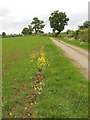
Bridleway and cycle route
The bridleway is a traffic-free part of National Cycle Route 51. The field has a wheat crop, not well advanced so probably sown in the spring. There is some yellow oilseed rape at the edge of the wheat, either seeded from a previous crop in the field or possibly just from seed blown in the wind.
Image: © David Hawgood
Taken: 18 May 2007
0.15 miles
2
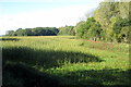
Fishpond Spinney at the far edge of the field
Image: © Philip Jeffrey
Taken: 12 Oct 2012
0.20 miles