IMAGES TAKEN NEAR TO
Wigwell Gardens, MILTON KEYNES, MK17 0QX
Introduction
This page details the photographs taken nearby to Wigwell Gardens, MK17 0QX by members of the Geograph project.
The Geograph project started in 2005 with the aim of publishing, organising and preserving representative images for every square kilometre of Great Britain, Ireland and the Isle of Man.

There are currently over 7.5m images from over14,400 individuals and you can help contribute to the project by visiting https://www.geograph.org.uk
Image Map
Images are licensed for reuse under creativecommons.org/licenses/by-sa/2.0
Notes
- Clicking on the map will re-center to the selected point.
- The higher the marker number, the further away the image location is from the centre of the postcode.
Image Listing (29 Images Found)
Images are licensed for reuse under creativecommons.org/licenses/by-sa/2.0
Image
Details
Distance

3
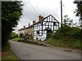
Great Horwood - Houses on Winslow Road
Image: © James Emmans
Taken: 24 Jul 2017
0.11 miles
4
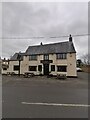
The Swan Inn Freehouse Great Horwood
Image: © Ryan Griffiths
Taken: 29 Jan 2022
0.12 miles
5
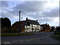
The Swan, Great Horwood
Charles Wells brewery pub
Image: © al partington
Taken: 16 Feb 2006
0.13 miles
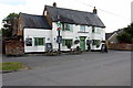
7
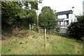
North Bucks Way comes into Great Horwood
Image: © Philip Jeffrey
Taken: 27 Sep 2012
0.15 miles