IMAGES TAKEN NEAR TO
MK17 0QT
Introduction
This page details the photographs taken nearby to MK17 0QT by members of the Geograph project.
The Geograph project started in 2005 with the aim of publishing, organising and preserving representative images for every square kilometre of Great Britain, Ireland and the Isle of Man.

There are currently over 7.5m images from over14,400 individuals and you can help contribute to the project by visiting https://www.geograph.org.uk
Image Map
Images are licensed for reuse under creativecommons.org/licenses/by-sa/2.0
Notes
- Clicking on the map will re-center to the selected point.
- The higher the marker number, the further away the image location is from the centre of the postcode.
Image Listing (23 Images Found)
Images are licensed for reuse under creativecommons.org/licenses/by-sa/2.0
Image
Details
Distance
2
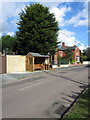
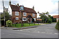
The Green, Great Horwood
Compare with a recent visit https://www.geograph.org.uk/photo/6354529
Image: © David Howard
Taken: 27 Jun 2020
0.02 miles
4
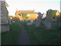
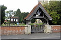
Churchyard of St James's Church
Churchyard of St James's Church Great Horwood
Image: © Shaun Ferguson
Taken: 20 Nov 2015
0.07 miles
6
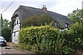
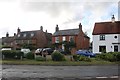
Thatched cottage on Little Horwood Road, Great Horwood
Image: © David Howard
Taken: 27 Jun 2020
0.08 miles
8
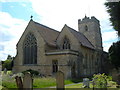
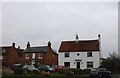
St James Church, Great Horwood
The local parish church dedicated to St James. Looks to have had many additions and alterations over the years.
Image: © Mr Biz
Taken: 15 Jun 2008
0.09 miles