IMAGES TAKEN NEAR TO
Mursley Road, MILTON KEYNES, MK17 0PH
Introduction
This page details the photographs taken nearby to Mursley Road, MK17 0PH by members of the Geograph project.
The Geograph project started in 2005 with the aim of publishing, organising and preserving representative images for every square kilometre of Great Britain, Ireland and the Isle of Man.

There are currently over 7.5m images from over14,400 individuals and you can help contribute to the project by visiting https://www.geograph.org.uk
Image Map
Images are licensed for reuse under creativecommons.org/licenses/by-sa/2.0
Notes
- Clicking on the map will re-center to the selected point.
- The higher the marker number, the further away the image location is from the centre of the postcode.
Image Listing (4 Images Found)
Images are licensed for reuse under creativecommons.org/licenses/by-sa/2.0
Image
Details
Distance
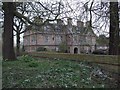
2
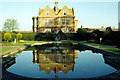
Horwood House
This house was at one time a GPO training centre, but is now a hotel and conference centre standing in attractive grounds.
Image: © Stephen McKay
Taken: Unknown
0.04 miles
3
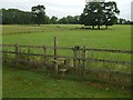
Horwood House footpath
Footpath looking away from Horwood House
Image: © Barry Ephgrave
Taken: 8 Jul 2009
0.08 miles
4
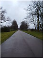
Driveway to Horwood House
This driveway leads to the Horwood House hotel and conference centre
Image: © Mr Biz
Taken: 19 Mar 2010
0.13 miles