IMAGES TAKEN NEAR TO
Church Hill, MILTON KEYNES, MK17 0LZ
Introduction
This page details the photographs taken nearby to Church Hill, MK17 0LZ by members of the Geograph project.
The Geograph project started in 2005 with the aim of publishing, organising and preserving representative images for every square kilometre of Great Britain, Ireland and the Isle of Man.

There are currently over 7.5m images from over14,400 individuals and you can help contribute to the project by visiting https://www.geograph.org.uk
Image Map
Images are licensed for reuse under creativecommons.org/licenses/by-sa/2.0
Notes
- Clicking on the map will re-center to the selected point.
- The higher the marker number, the further away the image location is from the centre of the postcode.
Image Listing (24 Images Found)
Images are licensed for reuse under creativecommons.org/licenses/by-sa/2.0
Image
Details
Distance
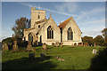
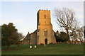
5
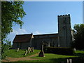
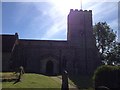
St.Mary's Church, Whaddon
Church in the village of Whaddon
Image: © Mr Biz
Taken: 13 May 2008
0.04 miles
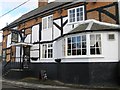
8

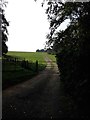
Nash Road in Whaddon
Looking north-westward.
Image: © Peter Wood
Taken: 6 Oct 2019
0.04 miles
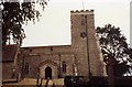
10
St Mary's Church
There is an OS benchmark Image on the buttress on the left hand corner of the tower whose centre and flagstaff are components of an OS trig point, http://trigpointing.uk/trig/19965
Image: © Roger Templeman
Taken: 2 Mar 2017
0.06 miles