IMAGES TAKEN NEAR TO
Thornton Road, MILTON KEYNES, MK17 0HA
Introduction
This page details the photographs taken nearby to Thornton Road, MK17 0HA by members of the Geograph project.
The Geograph project started in 2005 with the aim of publishing, organising and preserving representative images for every square kilometre of Great Britain, Ireland and the Isle of Man.

There are currently over 7.5m images from over14,400 individuals and you can help contribute to the project by visiting https://www.geograph.org.uk
Image Map
Images are licensed for reuse under creativecommons.org/licenses/by-sa/2.0
Notes
- Clicking on the map will re-center to the selected point.
- The higher the marker number, the further away the image location is from the centre of the postcode.
Image Listing (7 Images Found)
Images are licensed for reuse under creativecommons.org/licenses/by-sa/2.0
Image
Details
Distance
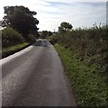
1
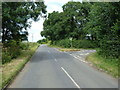
Road Junction
From the A421 this road heads towards Thornton, with the junction heading off towards Nash.
Image: © Mr Biz
Taken: 13 Jul 2008
0.04 miles
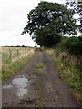
2
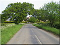
Road to Nash
Road to Nash at Tyrellcote Farm corner
Image: © Shaun Ferguson
Taken: 21 May 2010
0.04 miles
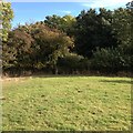
7
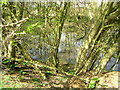
Small Pond
The southern tip of this rather small pond just clips this square. Not visible of the Modern or Historic online OS maps, this pond is however found on my '97 OS explorer map.
Image: © Mr Biz
Taken: 6 Apr 2007
0.24 miles