IMAGES TAKEN NEAR TO
Crabtree Close, MILTON KEYNES, MK17 0FP
Introduction
This page details the photographs taken nearby to Crabtree Close, MK17 0FP by members of the Geograph project.
The Geograph project started in 2005 with the aim of publishing, organising and preserving representative images for every square kilometre of Great Britain, Ireland and the Isle of Man.

There are currently over 7.5m images from over14,400 individuals and you can help contribute to the project by visiting https://www.geograph.org.uk
Image Map (Loading...)


Getting Data...Please wait
Leaflet Map data © OpenStreetMap
Images are licensed for reuse under creativecommons.org/licenses/by-sa/2.0
Notes
- Clicking on the map will re-center to the selected point.
- The higher the marker number, the further away the image location is from the centre of the postcode.
Image Listing (5 Images Found)
Images are licensed for reuse under creativecommons.org/licenses/by-sa/2.0
Image
Details
Distance
1
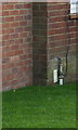
Benchmark on #16 Townsend Cottages
Ordnance Survey cut mark benchmark described on the Bench Mark Database at http://www.bench-marks.org.uk/bm80614
Image: © Roger Templeman
Taken: 23 Nov 2016
0.06 miles
2
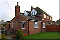
#16 Townsend Cottages, Little Horwood Road
There is an OS benchmark Image in the bricks at the near corner of the original house at its junction with its nearer extension.
Image: © Roger Templeman
Taken: 23 Nov 2016
0.06 miles
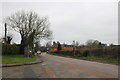
4
Tin garage on Little Horwood Road, Great Horwood
Image: © David Howard
Taken: 27 Jun 2020
0.19 miles
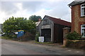
5
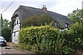
Thatched cottage on Little Horwood Road, Great Horwood
Image: © David Howard
Taken: 27 Jun 2020
0.24 miles