IMAGES TAKEN NEAR TO
Winslow Road, MILTON KEYNES, MK17 0EW
Introduction
This page details the photographs taken nearby to Winslow Road, MK17 0EW by members of the Geograph project.
The Geograph project started in 2005 with the aim of publishing, organising and preserving representative images for every square kilometre of Great Britain, Ireland and the Isle of Man.

There are currently over 7.5m images from over14,400 individuals and you can help contribute to the project by visiting https://www.geograph.org.uk
Image Map
Images are licensed for reuse under creativecommons.org/licenses/by-sa/2.0
Notes
- Clicking on the map will re-center to the selected point.
- The higher the marker number, the further away the image location is from the centre of the postcode.
Image Listing (29 Images Found)
Images are licensed for reuse under creativecommons.org/licenses/by-sa/2.0
Image
Details
Distance
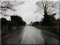
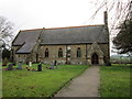
5
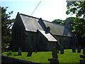
All Saints Church, Nash
The church in the village of Nash.
Image: © Mr Biz
Taken: 13 May 2008
0.09 miles
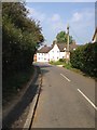
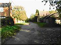
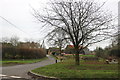
7

Weir Cottage in Nash (Wood End)
Westward view on Winslow Road.
Image: © Ben Brooksbank
Taken: 5 Feb 1997
0.13 miles
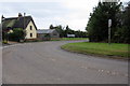
8
Wood End, Nash
Taken from beside the pond
Image: © Peter Franklin
Taken: 29 Oct 2006
0.14 miles
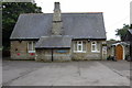
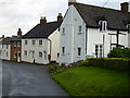
10
Wood End
The house on the left was built since 2009 and the concrete table arrived since then as well.
Image: © David Howard
Taken: 28 Dec 2019
0.14 miles