IMAGES TAKEN NEAR TO
Drayton Road, MILTON KEYNES, MK17 0BH
Introduction
This page details the photographs taken nearby to Drayton Road, MK17 0BH by members of the Geograph project.
The Geograph project started in 2005 with the aim of publishing, organising and preserving representative images for every square kilometre of Great Britain, Ireland and the Isle of Man.

There are currently over 7.5m images from over14,400 individuals and you can help contribute to the project by visiting https://www.geograph.org.uk
Image Map
Images are licensed for reuse under creativecommons.org/licenses/by-sa/2.0
Notes
- Clicking on the map will re-center to the selected point.
- The higher the marker number, the further away the image location is from the centre of the postcode.
Image Listing (4 Images Found)
Images are licensed for reuse under creativecommons.org/licenses/by-sa/2.0
Image
Details
Distance
2
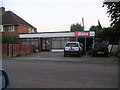
Fancy Dress Shop
Used to be the old local papershop in Newton Longville before it was sold and became a fancy dress shop.
Image: © Mr Biz
Taken: 24 Jul 2006
0.21 miles
4
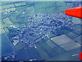
Newton Longville from the air
Looking north from above Drayton Parslow.
Image: © M J Richardson
Taken: 26 Jun 2015
0.21 miles